Darnah geodata
Darnah is a seat of a first-order administrative division; located in Libya in Africa/Tripoli (GMT+2) time zone. With population of 78,782 people, there are 18 cities with bigger population in this country. Compared to other cities in Libya, 90.6% of cities are located further ↓South; 90.6% of cities are located further ←West and 83% of cities have higher elevation than Darnah. Note1


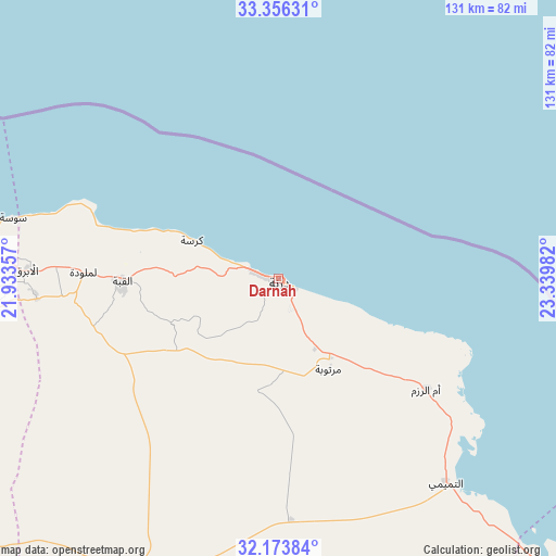
Darnah GPS coordinates[2]
32° 46' 1.344" North, 22° 38' 12.084" East
| Map corner | latitude | longitude |
|---|---|---|
| Upper-left | 33.35631°, | 21.93357° |
| Center: | 32.76704°, | 22.63669° |
| Lower-right: | 32.17384°, | 23.33982° |
| Map W x H: | 131.5×131.5 km | = 81.7×81.7mi |
| max Lat: | 32.94699° ⇑9.4% North |
| Darnah: | 32.76704° |
| min Lat: | ⇓90.6% South 24.1989° |
| min Long | Darnah | max Long |
| 9.50072° | 22.63669° | 25.0866° |
| W 90.6%⇐ | ⇒9.4% E |
Elevation
Elevation of Darnah is 9 m = 30 ft, and this is 223.2 m = 732 ft below average elevation for this country.
| Max E: |
704 m = 2310 ft | 83% |
| Avg. | 232.2 m = 762 ft | |
| Darnah | 9 m = 30 ft | |
Min E: |
3 m = 10 ft | 17% |
See also: Darnah elevation on elevation.city.
Geographical zone
Darnah is located in North temperate zone (between Tropic of Cancer and the Arctic Circle). Distance of this Northern Tropic circle is 1037.4 km =644.6 mi to South.| Distance of | km | miles | from Darnah |
|---|---|---|---|
| North Pole | 6363.7 | 3954.2 | to North |
| Arctic Circle | 3757.8 | 2335 | to North |
| Tropic Cancer | 1037.4 | 644.6 | to South |
| Equator | 3643.4 | 2263.9 | to South |


Nearby cities:
15 places around Darnah: (largest is in red/bold)
• Ajdabiya
319.3 km =198.4 mi,  225°
225°
• Al Abyār
201.8 km =125.4 mi,  251°
251°
• Al Bardīyah
256.3 km =159.3 mi,  116°
116°
• Al Bayḑā’
82.4 km =51.2 mi,  269°
269°
• Al Burayqah
391.2 km =243.1 mi, 227°
• Al Jaghbūb
380.8 km =236.6 mi,  152°
152°
• Al Marj
172 km =106.9 mi,  259°
259°
• Al Qubbah
37 km =23 mi, 268°
• Awjilah
426.7 km =265.1 mi,  197°
197°
• Az Zuwaytīnah
311.7 km =193.7 mi, 229°
• Benghazi
251.7 km =156.4 mi, 253°
• Gialo
427.9 km =265.9 mi,  194°
194°
• Qaryat Sulūq
255.4 km =158.7 mi,  241°
241°
• Tobruk
144.8 km =90 mi, 121°
• Tūkrah
194.4 km =120.8 mi, 262°
Sources, notices
• [Note1] Compared only with cities in Libya existing in our database
• [Src1] Map data: © OpenStreetMap contributors (CC-BY-SA)
• [Src2] Other city data from geonames.org with taken over terms of usage.
• [Src3] Geographical zone / Annual Mean Temperature by Robert A. Rohde @ Wikipedia
