Al Qubbah geodata
Al Qubbah (Darnah) is a populated place; located in Libya in Africa/Tripoli (GMT+2) time zone. With population of 24,631 people, there are 33 cities with bigger population in this country. Compared to other cities in Libya, 83% of cities are located further ↓South; 88.7% of cities are located further ←West and 86.8% of cities have lower elevation than Al Qubbah. Note1


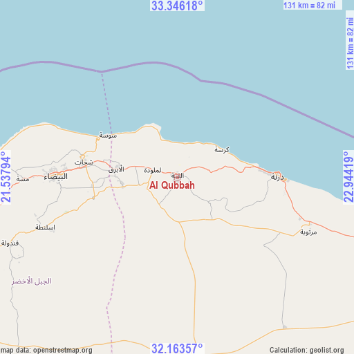
Al Qubbah GPS coordinates[2]
32° 45' 24.624" North, 22° 14' 27.816" East
| Map corner | latitude | longitude |
|---|---|---|
| Upper-left | 33.34618°, | 21.53794° |
| Center: | 32.75684°, | 22.24106° |
| Lower-right: | 32.16357°, | 22.94419° |
| Map W x H: | 131.5×131.5 km | = 81.7×81.7mi |
| max Lat: | 32.94699° ⇑17% North |
| Al Qubbah: | 32.75684° |
| min Lat: | ⇓83% South 24.1989° |
| min Long | Al Qubbah | max Long |
| 9.50072° | 22.24106° | 25.0866° |
| W 88.7%⇐ | ⇒11.3% E |
Elevation
Elevation of Al Qubbah is 614 m = 2014 ft, and this is 381.8 m = 1253 ft above average elevation for this country.
| Max E: |
704 m = 2310 ft | 13.2% |
| Al Qubbah | 614 m 2014 ft | |
| Avg. | 232.2 m = 762 ft | |
Min E: |
3 m = 10 ft | 86.8% |
See also: Libya elevation on elevation.city.
Geographical zone
Al Qubbah is located in North temperate zone (between Tropic of Cancer and the Arctic Circle). Distance of this Northern Tropic circle is 1036.3 km =643.9 mi to South.| Distance of | km | miles | from Al Qubbah |
|---|---|---|---|
| North Pole | 6364.8 | 3954.9 | to North |
| Arctic Circle | 3759 | 2335.7 | to North |
| Tropic Cancer | 1036.3 | 643.9 | to South |
| Equator | 3642.2 | 2263.2 | to South |


Nearby cities:
15 places around Al Qubbah: (largest is in red/bold)
• Ajdabiya
292.9 km =182 mi,  220°
220°
• Al Abyār
166.6 km =103.5 mi,  247°
247°
• Al Bardīyah
289.8 km =180.1 mi,  112°
112°
• Al Bayḑā’
45.4 km =28.2 mi,  270°
270°
• Al Burayqah
363.5 km =225.9 mi, 224°
• Al Jaghbūb
398.9 km =247.9 mi,  147°
147°
• Al Marj
135.4 km =84.1 mi,  257°
257°
• Awjilah
415.8 km =258.4 mi,  192°
192°
• Az Zuwaytīnah
283.5 km =176.2 mi, 224°
• Benghazi
216 km =134.2 mi, 250°
• Darnah
37 km =23 mi,  88°
88°
• Gialo
419.2 km =260.5 mi, 189°
• Qaryat Sulūq
222.8 km =138.4 mi,  237°
237°
• Tobruk
177 km =110 mi, 114°
• Tūkrah
157.6 km =97.9 mi, 260°
Sources, notices
• [Note1] Compared only with cities in Libya existing in our database
• [Src1] Map data: © OpenStreetMap contributors (CC-BY-SA)
• [Src2] Other city data from geonames.org with taken over terms of usage.
• [Src3] Geographical zone / Annual Mean Temperature by Robert A. Rohde @ Wikipedia
