Yenangyaung geodata
Yenangyaung (Magway) is a populated place; located in Myanmar in Asia/Yangon (GMT+6.5) time zone. With population of 110,553 people, there are 20 cities with bigger population in this country. Compared to other cities in Myanmar, 74.3% of cities are located further ↓South; 91.9% of cities are located further →East and 60.8% of cities have lower elevation than Yenangyaung. Note1


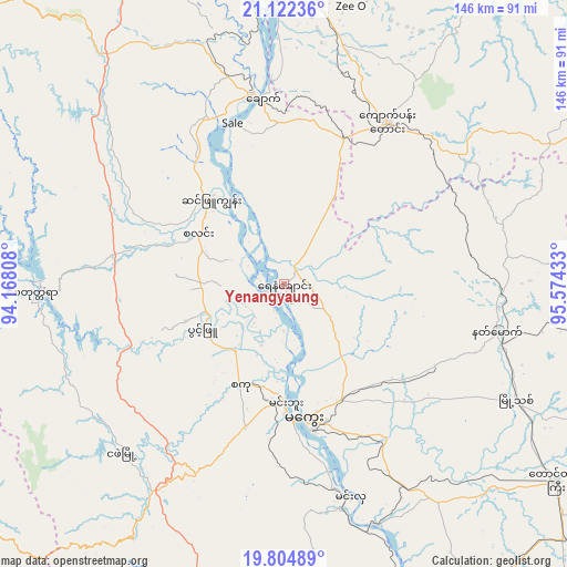
Yenangyaung GPS coordinates[2]
20° 27' 54.144" North, 94° 52' 16.32" East
| Map corner | latitude | longitude |
|---|---|---|
| Upper-left | 21.12236°, | 94.16808° |
| Center: | 20.46504°, | 94.8712° |
| Lower-right: | 19.80489°, | 95.57433° |
| Map W x H: | 146.5×146.5 km | = 91×91mi |
| max Lat: | 25.38327° ⇑25.7% North |
| Yenangyaung: | 20.46504° |
| min Lat: | ⇓74.3% South 9.98238° |
| min Long | Yenangyaung | max Long |
| 92.89835° | 94.8712° | 99.88083° |
| W 8.1%⇐ | ⇒91.9% E |
Elevation
Elevation of Yenangyaung is 56 m = 184 ft, and this is 132.9 m = 436 ft below average elevation for this country.
| Max E: |
1768 m = 5801 ft | 39.2% |
| Avg. | 188.9 m = 620 ft | |
| Yenangyaung | 56 m = 184 ft | |
Min E: |
5 m = 16 ft | 60.8% |
See also: Yenangyaung elevation on elevation.city.
Geographical zone
Yenangyaung is located in North Torrid zone (between Equator and Tropic of Cancer). Distance of this Northern Tropic circle is 330.4 km =205.3 mi to North.| Distance of | km | miles | from Yenangyaung |
|---|---|---|---|
| North Pole | 7731.6 | 4804.2 | to North |
| Arctic Circle | 5125.7 | 3185 | to North |
| Tropic Cancer | 330.4 | 205.3 | to North |
| Equator | 2275.5 | 1413.9 | to South |


Nearby cities:
15 places around Yenangyaung: (largest is in red/bold)
• Chauk
48.6 km =30.2 mi,  353°
353°
• Kyaukse
182.4 km =113.3 mi,  45°
45°
• Magway
35.7 km =22.2 mi,  169°
169°
• Meiktila
112.5 km =69.9 mi,  65°
65°
• Minbu
31.6 km =19.6 mi,  179°
179°
• Monywa
184.8 km =114.8 mi,  8°
8°
• Myaydo
127.1 km =79 mi,  163°
163°
• Myingyan
123 km =76.4 mi,  25°
25°
• Nay Pyi Taw
153.9 km =95.6 mi,  121°
121°
• Pakokku
99.2 km =61.6 mi, 12°
• Pyay
186.1 km =115.6 mi, 168°
• Pyinmana
161.2 km =100.2 mi, 120°
• Taungdwingyi
86.9 km =54 mi,  125°
125°
• Thayetmyo
131.3 km =81.6 mi, 165°
• Yamethin
132.1 km =82.1 mi,  91°
91°
Sources, notices
• [Note1] Compared only with cities in Myanmar existing in our database
• [Src1] Map data: © OpenStreetMap contributors (CC-BY-SA)
• [Src2] Other city data from geonames.org with taken over terms of usage.
• [Src3] Geographical zone / Annual Mean Temperature by Robert A. Rohde @ Wikipedia
