Pakokku geodata
Pakokku (Magway) is a populated place; located in Myanmar in Asia/Yangon (GMT+6.5) time zone. With population of 126,938 people, there are 17 cities with bigger population in this country. Compared to other cities in Myanmar, 81.1% of cities are located further ↓South; 87.8% of cities are located further →East and 66.2% of cities have lower elevation than Pakokku. Note1


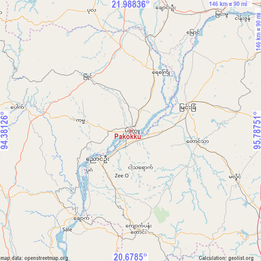
Pakokku GPS coordinates[2]
21° 20' 5.604" North, 95° 5' 3.768" East
| Map corner | latitude | longitude |
|---|---|---|
| Upper-left | 21.98836°, | 94.38126° |
| Center: | 21.33489°, | 95.08438° |
| Lower-right: | 20.6785°, | 95.78751° |
| Map W x H: | 145.6×145.6 km | = 90.5×90.5mi |
| max Lat: | 25.38327° ⇑18.9% North |
| Pakokku: | 21.33489° |
| min Lat: | ⇓81.1% South 9.98238° |
| min Long | Pakokku | max Long |
| 92.89835° | 95.08438° | 99.88083° |
| W 12.2%⇐ | ⇒87.8% E |
Elevation
Elevation of Pakokku is 70 m = 230 ft, and this is 118.9 m = 390 ft below average elevation for this country.
| Max E: |
1768 m = 5801 ft | 33.8% |
| Avg. | 188.9 m = 620 ft | |
| Pakokku | 70 m = 230 ft | |
Min E: |
5 m = 16 ft | 66.2% |
See also: Pakokku elevation on elevation.city.
Geographical zone
Pakokku is located in North Torrid zone (between Equator and Tropic of Cancer). Distance of this Northern Tropic circle is 233.7 km =145.2 mi to North.| Distance of | km | miles | from Pakokku |
|---|---|---|---|
| North Pole | 7634.8 | 4744 | to North |
| Arctic Circle | 5029 | 3124.9 | to North |
| Tropic Cancer | 233.7 | 145.2 | to North |
| Equator | 2372.2 | 1474 | to South |


Nearby cities:
15 places around Pakokku: (largest is in red/bold)
• Chauk
55.8 km =34.7 mi,  209°
209°
• Kyaukse
112.8 km =70.1 mi,  74°
74°
• Magway
132.7 km =82.5 mi,  186°
186°
• Mandalay
125.4 km =77.9 mi,  55°
55°
• Meiktila
95 km =59 mi,  122°
122°
• Minbu
130.2 km =80.9 mi, 189°
• Monywa
86.2 km =53.6 mi,  3°
3°
• Myingyan
34.4 km =21.4 mi, 66°
• Nyaungshwe
206.1 km =128.1 mi,  111°
111°
• Pyin Oo Lwin
161.8 km =100.5 mi, 61°
• Sagaing
110.6 km =68.7 mi, 56°
• Shwebo
151.1 km =93.9 mi,  24°
24°
• Taungdwingyi
155.3 km =96.5 mi,  162°
162°
• Yamethin
148.6 km =92.3 mi,  132°
132°
• Yenangyaung
99.2 km =61.6 mi, 192°
Sources, notices
• [Note1] Compared only with cities in Myanmar existing in our database
• [Src1] Map data: © OpenStreetMap contributors (CC-BY-SA)
• [Src2] Other city data from geonames.org with taken over terms of usage.
• [Src3] Geographical zone / Annual Mean Temperature by Robert A. Rohde @ Wikipedia
