Magway geodata
Magway is a seat of a first-order administrative division; located in Myanmar in Asia/Yangon (GMT+6.5) time zone. With population of 96,954 people, there are 24 cities with bigger population in this country. Compared to other cities in Myanmar, 67.6% of cities are located further ↓South; 89.2% of cities are located further →East and 64.9% of cities have lower elevation than Magway. Note1


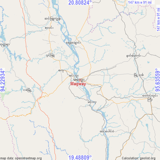
Magway GPS coordinates[2]
20° 8' 58.416" North, 94° 55' 56.856" East
| Map corner | latitude | longitude |
|---|---|---|
| Upper-left | 20.80824°, | 94.22934° |
| Center: | 20.14956°, | 94.93246° |
| Lower-right: | 19.48809°, | 95.63559° |
| Map W x H: | 146.8×146.8 km | = 91.2×91.2mi |
| max Lat: | 25.38327° ⇑32.4% North |
| Magway: | 20.14956° |
| min Lat: | ⇓67.6% South 9.98238° |
| min Long | Magway | max Long |
| 92.89835° | 94.93246° | 99.88083° |
| W 10.8%⇐ | ⇒89.2% E |
Elevation
Elevation of Magway is 60 m = 197 ft, and this is 128.9 m = 423 ft below average elevation for this country.
| Max E: |
1768 m = 5801 ft | 35.1% |
| Avg. | 188.9 m = 620 ft | |
| Magway | 60 m = 197 ft | |
Min E: |
5 m = 16 ft | 64.9% |
See also: Magway elevation on elevation.city.
Geographical zone
Magway is located in North Torrid zone (between Equator and Tropic of Cancer). Distance of this Northern Tropic circle is 365.5 km =227.1 mi to North.| Distance of | km | miles | from Magway |
|---|---|---|---|
| North Pole | 7766.6 | 4825.9 | to North |
| Arctic Circle | 5160.8 | 3206.8 | to North |
| Tropic Cancer | 365.5 | 227.1 | to North |
| Equator | 2240.4 | 1392.1 | to South |


Nearby cities:
15 places around Magway: (largest is in red/bold)
• Chauk
84.2 km =52.3 mi,  351°
351°
• Indein
202.1 km =125.6 mi,  80°
80°
• Meiktila
125.9 km =78.2 mi,  49°
49°
• Minbu
6.8 km =4.2 mi,  300°
300°
• Myaydo
91.8 km =57 mi,  161°
161°
• Myingyan
153.2 km =95.2 mi,  18°
18°
• Nay Pyi Taw
133 km =82.6 mi,  109°
109°
• Pakokku
132.7 km =82.5 mi,  6°
6°
• Paungde
193.9 km =120.5 mi, 161°
• Pyay
150.4 km =93.5 mi,  168°
168°
• Pyinmana
140.9 km =87.6 mi, 108°
• Taungdwingyi
65.9 km =40.9 mi,  103°
103°
• Thayetmyo
95.8 km =59.5 mi, 164°
• Yamethin
129.7 km =80.6 mi, 75°
• Yenangyaung
35.7 km =22.2 mi, 349°
Sources, notices
• [Note1] Compared only with cities in Myanmar existing in our database
• [Src1] Map data: © OpenStreetMap contributors (CC-BY-SA)
• [Src2] Other city data from geonames.org with taken over terms of usage.
• [Src3] Geographical zone / Annual Mean Temperature by Robert A. Rohde @ Wikipedia
