Monywa geodata
Monywa (Sagain) is a populated place; located in Myanmar in Asia/Yangon (GMT+6.5) time zone. With population of 182,011 people, there are 7 cities with bigger population in this country. Compared to other cities in Myanmar, 89.2% of cities are located further ↓South; 86.5% of cities are located further →East and 70.3% of cities have lower elevation than Monywa. Note1


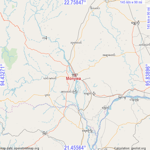
Monywa GPS coordinates[2]
22° 6' 30.816" North, 95° 8' 8.988" East
| Map corner | latitude | longitude |
|---|---|---|
| Upper-left | 22.75847°, | 94.43271° |
| Center: | 22.10856°, | 95.13583° |
| Lower-right: | 21.45564°, | 95.83896° |
| Map W x H: | 144.9×144.9 km | = 90×90mi |
| max Lat: | 25.38327° ⇑10.8% North |
| Monywa: | 22.10856° |
| min Lat: | ⇓89.2% South 9.98238° |
| min Long | Monywa | max Long |
| 92.89835° | 95.13583° | 99.88083° |
| W 13.5%⇐ | ⇒86.5% E |
Elevation
Elevation of Monywa is 81 m = 266 ft, and this is 107.9 m = 354 ft below average elevation for this country.
| Max E: |
1768 m = 5801 ft | 29.7% |
| Avg. | 188.9 m = 620 ft | |
| Monywa | 81 m = 266 ft | |
Min E: |
5 m = 16 ft | 70.3% |
See also: Monywa elevation on elevation.city.
Geographical zone
Monywa is located in North Torrid zone (between Equator and Tropic of Cancer). Distance of this Northern Tropic circle is 147.7 km =91.8 mi to North.| Distance of | km | miles | from Monywa |
|---|---|---|---|
| North Pole | 7548.8 | 4690.6 | to North |
| Arctic Circle | 4942.9 | 3071.4 | to North |
| Tropic Cancer | 147.7 | 91.8 | to North |
| Equator | 2458.2 | 1527.5 | to South |


Nearby cities:
15 places around Monywa: (largest is in red/bold)
• Chauk
138.4 km =86 mi,  193°
193°
• Falam
174.5 km =108.4 mi,  300°
300°
• Hakha
167.7 km =104.2 mi,  290°
290°
• Kyaukse
117.3 km =72.9 mi,  118°
118°
• Mandalay
98.8 km =61.4 mi,  98°
98°
• Mawlaik
186.3 km =115.8 mi,  336°
336°
• Meiktila
155.9 km =96.9 mi,  151°
151°
• Mogok
167.4 km =104 mi,  57°
57°
• Myingyan
76.7 km =47.7 mi,  160°
160°
• Pakokku
86.2 km =53.6 mi,  183°
183°
• Pyin Oo Lwin
136.4 km =84.8 mi,  93°
93°
• Sagaing
90.7 km =56.4 mi,  106°
106°
• Shwebo
77.3 km =48 mi,  48°
48°
• Yamethin
213.4 km =132.6 mi, 150°
• Yenangyaung
184.8 km =114.8 mi, 188°
Sources, notices
• [Note1] Compared only with cities in Myanmar existing in our database
• [Src1] Map data: © OpenStreetMap contributors (CC-BY-SA)
• [Src2] Other city data from geonames.org with taken over terms of usage.
• [Src3] Geographical zone / Annual Mean Temperature by Robert A. Rohde @ Wikipedia
