Thayetmyo geodata
Thayetmyo (Magway) is a populated place; located in Myanmar in Asia/Yangon (GMT+6.5) time zone. With population of 98,185 people, there are 22 cities with bigger population in this country. Compared to other cities in Myanmar, 58.1% of cities are located further ↓South; 85.1% of cities are located further →East and 54.1% of cities have lower elevation than Thayetmyo. Note1


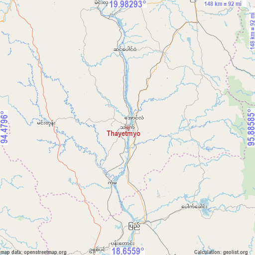
Thayetmyo GPS coordinates[2]
19° 19' 14.736" North, 95° 10' 57.792" East
| Map corner | latitude | longitude |
|---|---|---|
| Upper-left | 19.98293°, | 94.4796° |
| Center: | 19.32076°, | 95.18272° |
| Lower-right: | 18.6559°, | 95.88585° |
| Map W x H: | 147.6×147.6 km | = 91.7×91.7mi |
| max Lat: | 25.38327° ⇑41.9% North |
| Thayetmyo: | 19.32076° |
| min Lat: | ⇓58.1% South 9.98238° |
| min Long | Thayetmyo | max Long |
| 92.89835° | 95.18272° | 99.88083° |
| W 14.9%⇐ | ⇒85.1% E |
Elevation
Elevation of Thayetmyo is 47 m = 154 ft, and this is 141.9 m = 466 ft below average elevation for this country.
| Max E: |
1768 m = 5801 ft | 45.9% |
| Avg. | 188.9 m = 620 ft | |
| Thayetmyo | 47 m = 154 ft | |
Min E: |
5 m = 16 ft | 54.1% |
See also: Thayetmyo elevation on elevation.city.
Geographical zone
Thayetmyo is located in North Torrid zone (between Equator and Tropic of Cancer). Distance of this Northern Tropic circle is 457.7 km =284.4 mi to North.| Distance of | km | miles | from Thayetmyo |
|---|---|---|---|
| North Pole | 7858.8 | 4883.2 | to North |
| Arctic Circle | 5252.9 | 3264 | to North |
| Tropic Cancer | 457.7 | 284.4 | to North |
| Equator | 2148.3 | 1334.9 | to South |


Nearby cities:
15 places around Thayetmyo: (largest is in red/bold)
• Chauk
179.6 km =111.6 mi,  347°
347°
• Letpandan
180.8 km =112.3 mi,  160°
160°
• Magway
95.8 km =59.5 mi,  344°
344°
• Minbu
100.9 km =62.7 mi, 341°
• Myanaung
115.9 km =72 mi,  172°
172°
• Myaydo
6.3 km =3.9 mi,  32°
32°
• Nay Pyi Taw
109.9 km =68.3 mi,  64°
64°
• Paungde
98.3 km =61.1 mi, 159°
• Pyay
55.3 km =34.4 mi,  175°
175°
• Pyinmana
117 km =72.7 mi,  66°
66°
• Pyu
161.7 km =100.5 mi,  125°
125°
• Taungdwingyi
85.2 km =52.9 mi, 26°
• Taungoo
138 km =85.7 mi,  107°
107°
• Yamethin
158.9 km =98.7 mi,  38°
38°
• Yenangyaung
131.3 km =81.6 mi, 345°
Sources, notices
• [Note1] Compared only with cities in Myanmar existing in our database
• [Src1] Map data: © OpenStreetMap contributors (CC-BY-SA)
• [Src2] Other city data from geonames.org with taken over terms of usage.
• [Src3] Geographical zone / Annual Mean Temperature by Robert A. Rohde @ Wikipedia
