Myingyan geodata
Myingyan (Mandalay) is a populated place; located in Myanmar in Asia/Yangon (GMT+6.5) time zone. With population of 141,713 people, there are 12 cities with bigger population in this country. Compared to other cities in Myanmar, 82.4% of cities are located further ↓South; 77% of cities are located further →East and 68.9% of cities have lower elevation than Myingyan. Note1


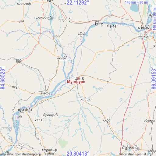
Myingyan GPS coordinates[2]
21° 27' 36.072" North, 95° 23' 18.24" East
| Map corner | latitude | longitude |
|---|---|---|
| Upper-left | 22.11292°, | 94.68528° |
| Center: | 21.46002°, | 95.3884° |
| Lower-right: | 20.80418°, | 96.09153° |
| Map W x H: | 145.5×145.5 km | = 90.4×90.4mi |
| max Lat: | 25.38327° ⇑17.6% North |
| Myingyan: | 21.46002° |
| min Lat: | ⇓82.4% South 9.98238° |
| min Long | Myingyan | max Long |
| 92.89835° | 95.3884° | 99.88083° |
| W 23%⇐ | ⇒77% E |
Elevation
Elevation of Myingyan is 76 m = 249 ft, and this is 112.9 m = 370 ft below average elevation for this country.
| Max E: |
1768 m = 5801 ft | 31.1% |
| Avg. | 188.9 m = 620 ft | |
| Myingyan | 76 m = 249 ft | |
Min E: |
5 m = 16 ft | 68.9% |
See also: Myingyan elevation on elevation.city.
Geographical zone
Myingyan is located in North Torrid zone (between Equator and Tropic of Cancer). Distance of this Northern Tropic circle is 219.8 km =136.6 mi to North.| Distance of | km | miles | from Myingyan |
|---|---|---|---|
| North Pole | 7620.9 | 4735.4 | to North |
| Arctic Circle | 5015 | 3116.2 | to North |
| Tropic Cancer | 219.8 | 136.6 | to North |
| Equator | 2386.1 | 1482.7 | to South |


Nearby cities:
15 places around Myingyan: (largest is in red/bold)
• Chauk
86 km =53.4 mi,  223°
223°
• Kyaukse
78.9 km =49 mi,  78°
78°
• Magway
153.2 km =95.2 mi,  198°
198°
• Mandalay
91.8 km =57 mi,  51°
51°
• Meiktila
81 km =50.3 mi,  143°
143°
• Minbu
151.9 km =94.4 mi, 200°
• Monywa
76.7 km =47.7 mi,  340°
340°
• Nyaungshwe
183.3 km =113.9 mi,  118°
118°
• Pakokku
34.4 km =21.4 mi,  246°
246°
• Pyin Oo Lwin
127.5 km =79.2 mi,  59°
59°
• Sagaing
76.8 km =47.7 mi, 52°
• Shwebo
127.4 km =79.2 mi,  14°
14°
• Taungdwingyi
162.4 km =100.9 mi,  174°
174°
• Yamethin
138.3 km =85.9 mi,  145°
145°
• Yenangyaung
123 km =76.4 mi,  205°
205°
Sources, notices
• [Note1] Compared only with cities in Myanmar existing in our database
• [Src1] Map data: © OpenStreetMap contributors (CC-BY-SA)
• [Src2] Other city data from geonames.org with taken over terms of usage.
• [Src3] Geographical zone / Annual Mean Temperature by Robert A. Rohde @ Wikipedia
