Chauk geodata
Chauk (Magway) is a populated place; located in Myanmar in Asia/Yangon (GMT+6.5) time zone. With population of 90,870 people, there are 26 cities with bigger population in this country. Compared to other cities in Myanmar, 79.7% of cities are located further ↓South; 93.2% of cities are located further →East and 63.5% of cities have lower elevation than Chauk. Note1


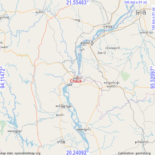
Chauk GPS coordinates[2]
20° 53' 57.156" North, 94° 49' 4.224" East
| Map corner | latitude | longitude |
|---|---|---|
| Upper-left | 21.55463°, | 94.11472° |
| Center: | 20.89921°, | 94.81784° |
| Lower-right: | 20.24092°, | 95.52097° |
| Map W x H: | 146.1×146.1 km | = 90.8×90.8mi |
| max Lat: | 25.38327° ⇑20.3% North |
| Chauk: | 20.89921° |
| min Lat: | ⇓79.7% South 9.98238° |
| min Long | Chauk | max Long |
| 92.89835° | 94.81784° | 99.88083° |
| W 6.8%⇐ | ⇒93.2% E |
Elevation
Elevation of Chauk is 59 m = 194 ft, and this is 129.9 m = 426 ft below average elevation for this country.
| Max E: |
1768 m = 5801 ft | 36.5% |
| Avg. | 188.9 m = 620 ft | |
| Chauk | 59 m = 194 ft | |
Min E: |
5 m = 16 ft | 63.5% |
See also: Chauk elevation on elevation.city.
Geographical zone
Chauk is located in North Torrid zone (between Equator and Tropic of Cancer). Distance of this Northern Tropic circle is 282.1 km =175.3 mi to North.| Distance of | km | miles | from Chauk |
|---|---|---|---|
| North Pole | 7683.3 | 4774.2 | to North |
| Arctic Circle | 5077.4 | 3154.9 | to North |
| Tropic Cancer | 282.1 | 175.3 | to North |
| Equator | 2323.8 | 1443.9 | to South |


Nearby cities:
15 places around Chauk: (largest is in red/bold)
• Kyaukse
157.5 km =97.9 mi,  60°
60°
• Magway
84.2 km =52.3 mi,  171°
171°
• Mandalay
177.4 km =110.2 mi,  47°
47°
• Meiktila
108.1 km =67.2 mi,  91°
91°
• Minbu
80.1 km =49.8 mi,  175°
175°
• Monywa
138.4 km =86 mi,  13°
13°
• Myaydo
175.2 km =108.9 mi, 166°
• Myingyan
86 km =53.4 mi,  43°
43°
• Nay Pyi Taw
187.6 km =116.6 mi,  133°
133°
• Pakokku
55.8 km =34.7 mi,  29°
29°
• Sagaing
162.3 km =100.8 mi, 47°
• Taungdwingyi
124.9 km =77.6 mi,  142°
142°
• Thayetmyo
179.6 km =111.6 mi, 167°
• Yamethin
146.9 km =91.3 mi,  110°
110°
• Yenangyaung
48.6 km =30.2 mi, 173°
Sources, notices
• [Note1] Compared only with cities in Myanmar existing in our database
• [Src1] Map data: © OpenStreetMap contributors (CC-BY-SA)
• [Src2] Other city data from geonames.org with taken over terms of usage.
• [Src3] Geographical zone / Annual Mean Temperature by Robert A. Rohde @ Wikipedia
