Taungdwingyi geodata
Taungdwingyi (Magway) is a populated place; located in Myanmar in Asia/Yangon (GMT+6.5) time zone. With population of 70,094 people, there are 32 cities with bigger population in this country. Compared to other cities in Myanmar, 64.9% of cities are located further ↓South; 71.6% of cities are located further →East and 81.1% of cities have lower elevation than Taungdwingyi. Note1


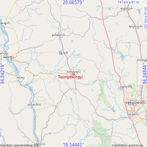
Taungdwingyi GPS coordinates[2]
20° 0' 23.4" North, 95° 32' 43.116" East
| Map corner | latitude | longitude |
|---|---|---|
| Upper-left | 20.66579°, | 94.84219° |
| Center: | 20.0065°, | 95.54531° |
| Lower-right: | 19.34443°, | 96.24844° |
| Map W x H: | 146.9×146.9 km | = 91.3×91.3mi |
| max Lat: | 25.38327° ⇑35.1% North |
| Taungdwingyi: | 20.0065° |
| min Lat: | ⇓64.9% South 9.98238° |
| min Long | Taungdwingyi | max Long |
| 92.89835° | 95.54531° | 99.88083° |
| W 28.4%⇐ | ⇒71.6% E |
Elevation
Elevation of Taungdwingyi is 143 m = 469 ft, and this is 45.9 m = 151 ft below average elevation for this country.
| Max E: |
1768 m = 5801 ft | 18.9% |
| Avg. | 188.9 m = 620 ft | |
| Taungdwingyi | 143 m = 469 ft | |
Min E: |
5 m = 16 ft | 81.1% |
See also: Taungdwingyi elevation on elevation.city.
Geographical zone
Taungdwingyi is located in North Torrid zone (between Equator and Tropic of Cancer). Distance of this Northern Tropic circle is 381.4 km =237 mi to North.| Distance of | km | miles | from Taungdwingyi |
|---|---|---|---|
| North Pole | 7782.5 | 4835.8 | to North |
| Arctic Circle | 5176.7 | 3216.7 | to North |
| Tropic Cancer | 381.4 | 237 | to North |
| Equator | 2224.5 | 1382.2 | to South |


Nearby cities:
15 places around Taungdwingyi: (largest is in red/bold)
• Chauk
124.9 km =77.6 mi,  322°
322°
• Indein
144.4 km =89.7 mi,  69°
69°
• Magway
65.9 km =40.9 mi,  283°
283°
• Meiktila
102.2 km =63.5 mi,  18°
18°
• Minbu
72.5 km =45 mi,  285°
285°
• Myaydo
78.9 km =49 mi,  205°
205°
• Nay Pyi Taw
67.7 km =42.1 mi,  115°
115°
• Nyaungshwe
162 km =100.7 mi,  63°
63°
• Pakokku
155.3 km =96.5 mi,  342°
342°
• Pyay
135.7 km =84.3 mi,  194°
194°
• Pyinmana
75.4 km =46.9 mi,  113°
113°
• Taungoo
150.6 km =93.6 mi,  141°
141°
• Thayetmyo
85.2 km =52.9 mi, 206°
• Yamethin
77.9 km =48.4 mi,  52°
52°
• Yenangyaung
86.9 km =54 mi,  305°
305°
Sources, notices
• [Note1] Compared only with cities in Myanmar existing in our database
• [Src1] Map data: © OpenStreetMap contributors (CC-BY-SA)
• [Src2] Other city data from geonames.org with taken over terms of usage.
• [Src3] Geographical zone / Annual Mean Temperature by Robert A. Rohde @ Wikipedia
