Minbu geodata
Minbu (Magway) is a populated place; located in Myanmar in Asia/Yangon (GMT+6.5) time zone. With population of 57,342 people, there are 40 cities with bigger population in this country. Compared to other cities in Myanmar, 68.9% of cities are located further ↓South; 90.5% of cities are located further →East and 56.8% of cities have lower elevation than Minbu. Note1


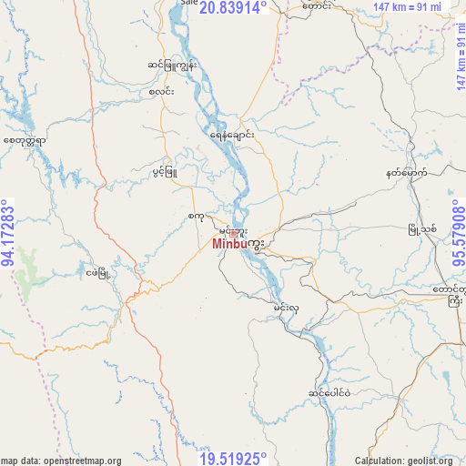
Minbu GPS coordinates[2]
20° 10' 50.124" North, 94° 52' 33.42" East
| Map corner | latitude | longitude |
|---|---|---|
| Upper-left | 20.83914°, | 94.17283° |
| Center: | 20.18059°, | 94.87595° |
| Lower-right: | 19.51925°, | 95.57908° |
| Map W x H: | 146.8×146.8 km | = 91.2×91.2mi |
| max Lat: | 25.38327° ⇑31.1% North |
| Minbu: | 20.18059° |
| min Lat: | ⇓68.9% South 9.98238° |
| min Long | Minbu | max Long |
| 92.89835° | 94.87595° | 99.88083° |
| W 9.5%⇐ | ⇒90.5% E |
Elevation
Elevation of Minbu is 49 m = 161 ft, and this is 139.9 m = 459 ft below average elevation for this country.
| Max E: |
1768 m = 5801 ft | 43.2% |
| Avg. | 188.9 m = 620 ft | |
| Minbu | 49 m = 161 ft | |
Min E: |
5 m = 16 ft | 56.8% |
See also: Minbu elevation on elevation.city.
Geographical zone
Minbu is located in North Torrid zone (between Equator and Tropic of Cancer). Distance of this Northern Tropic circle is 362 km =224.9 mi to North.| Distance of | km | miles | from Minbu |
|---|---|---|---|
| North Pole | 7763.2 | 4823.8 | to North |
| Arctic Circle | 5157.3 | 3204.6 | to North |
| Tropic Cancer | 362 | 224.9 | to North |
| Equator | 2243.9 | 1394.3 | to South |


Nearby cities:
15 places around Minbu: (largest is in red/bold)
• Chauk
80.1 km =49.8 mi,  355°
355°
• Kyaukse
205.5 km =127.7 mi,  39°
39°
• Magway
6.8 km =4.2 mi,  120°
120°
• Meiktila
128.4 km =79.8 mi,  52°
52°
• Myaydo
97 km =60.3 mi,  158°
158°
• Myingyan
151.9 km =94.4 mi,  20°
20°
• Nay Pyi Taw
139.7 km =86.8 mi,  110°
110°
• Pakokku
130.2 km =80.9 mi,  9°
9°
• Paungde
199.1 km =123.7 mi, 160°
• Pyay
155.1 km =96.4 mi,  166°
166°
• Pyinmana
147.6 km =91.7 mi, 109°
• Taungdwingyi
72.5 km =45 mi, 105°
• Thayetmyo
100.9 km =62.7 mi, 161°
• Yamethin
134.6 km =83.6 mi,  78°
78°
• Yenangyaung
31.6 km =19.6 mi, 359°
Sources, notices
• [Note1] Compared only with cities in Myanmar existing in our database
• [Src1] Map data: © OpenStreetMap contributors (CC-BY-SA)
• [Src2] Other city data from geonames.org with taken over terms of usage.
• [Src3] Geographical zone / Annual Mean Temperature by Robert A. Rohde @ Wikipedia
