Paungde geodata
Paungde (Bago) is a populated place; located in Myanmar in Asia/Yangon (GMT+6.5) time zone. With population of 36,971 people, there are 63 cities with bigger population in this country. Compared to other cities in Myanmar, 54.1% of cities are located further ↓South; 73% of cities are located further →East and 50% of cities have lower elevation than Paungde. Note1


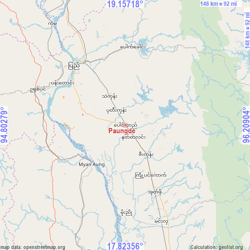
Paungde GPS coordinates[2]
18° 29' 30.012" North, 95° 30' 21.276" East
| Map corner | latitude | longitude |
|---|---|---|
| Upper-left | 19.15718°, | 94.80279° |
| Center: | 18.49167°, | 95.50591° |
| Lower-right: | 17.82356°, | 96.20904° |
| Map W x H: | 148.3×148.3 km | = 92.1×92.1mi |
| max Lat: | 25.38327° ⇑45.9% North |
| Paungde: | 18.49167° |
| min Lat: | ⇓54.1% South 9.98238° |
| min Long | Paungde | max Long |
| 92.89835° | 95.50591° | 99.88083° |
| W 27%⇐ | ⇒73% E |
Elevation
Elevation of Paungde is 35 m = 115 ft, and this is 153.9 m = 505 ft below average elevation for this country.
| Max E: |
1768 m = 5801 ft | 50% |
| Avg. | 188.9 m = 620 ft | |
| Paungde | 35 m = 115 ft | |
Min E: |
5 m = 16 ft | 50% |
See also: Myanmar elevation on elevation.city.
Geographical zone
Paungde is located in North Torrid zone (between Equator and Tropic of Cancer). Distance of this Northern Tropic circle is 549.8 km =341.6 mi to North.| Distance of | km | miles | from Paungde |
|---|---|---|---|
| North Pole | 7951 | 4940.5 | to North |
| Arctic Circle | 5345.1 | 3321.3 | to North |
| Tropic Cancer | 549.8 | 341.6 | to North |
| Equator | 2056.1 | 1277.6 | to South |


Nearby cities:
15 places around Paungde: (largest is in red/bold)
• Bago
164.9 km =102.5 mi,  141°
141°
• Hinthada
93.8 km =58.3 mi,  183°
183°
• Letpandan
82.6 km =51.3 mi,  161°
161°
• Myanaung
30.1 km =18.7 mi,  220°
220°
• Myaydo
102.2 km =63.5 mi,  342°
342°
• Nay Pyi Taw
154 km =95.7 mi,  25°
25°
• Nyaungdon
161.5 km =100.4 mi,  174°
174°
• Nyaunglebin
141.7 km =88 mi,  114°
114°
• Pyay
47.6 km =29.6 mi,  321°
321°
• Pyinmana
157 km =97.6 mi, 28°
• Pyu
98.2 km =61 mi,  90°
90°
• Taungdwingyi
168.5 km =104.7 mi,  1°
1°
• Taungoo
109.9 km =68.3 mi,  62°
62°
• Tharyarwady
97.8 km =60.8 mi, 162°
• Thayetmyo
98.3 km =61.1 mi, 339°
Sources, notices
• [Note1] Compared only with cities in Myanmar existing in our database
• [Src1] Map data: © OpenStreetMap contributors (CC-BY-SA)
• [Src2] Other city data from geonames.org with taken over terms of usage.
• [Src3] Geographical zone / Annual Mean Temperature by Robert A. Rohde @ Wikipedia
