Mandalay geodata
Mandalay is a seat of a first-order administrative division; located in Myanmar in Asia/Yangon (GMT+6.5) time zone. With population of 1,208,099 people, there is 1 city with bigger population in this country. Compared to other cities in Myanmar, 86.5% of cities are located further ↓South; 55.4% of cities are located further →East and 71.6% of cities have lower elevation than Mandalay. Note1


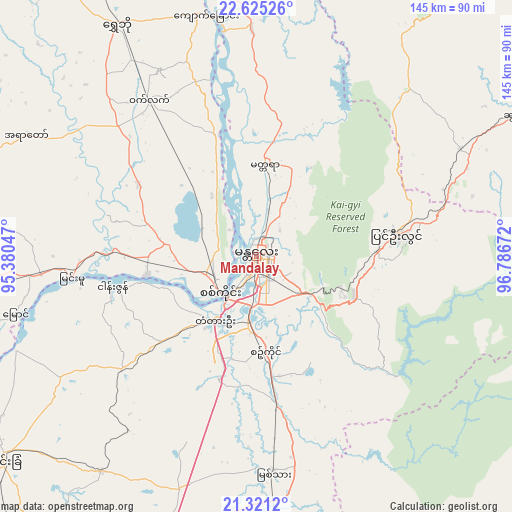
Mandalay GPS coordinates[2]
21° 58' 29.028" North, 96° 5' 0.924" East
| Map corner | latitude | longitude |
|---|---|---|
| Upper-left | 22.62526°, | 95.38047° |
| Center: | 21.97473°, | 96.08359° |
| Lower-right: | 21.3212°, | 96.78672° |
| Map W x H: | 145×145 km | = 90.1×90.1mi |
| max Lat: | 25.38327° ⇑13.5% North |
| Mandalay: | 21.97473° |
| min Lat: | ⇓86.5% South 9.98238° |
| min Long | Mandalay | max Long |
| 92.89835° | 96.08359° | 99.88083° |
| W 44.6%⇐ | ⇒55.4% E |
Elevation
Elevation of Mandalay is 83 m = 272 ft, and this is 105.9 m = 347 ft below average elevation for this country.
| Max E: |
1768 m = 5801 ft | 28.4% |
| Avg. | 188.9 m = 620 ft | |
| Mandalay | 83 m = 272 ft | |
Min E: |
5 m = 16 ft | 71.6% |
See also: Mandalay elevation on elevation.city.
Geographical zone
Mandalay is located in North Torrid zone (between Equator and Tropic of Cancer). Distance of this Northern Tropic circle is 162.6 km =101 mi to North.| Distance of | km | miles | from Mandalay |
|---|---|---|---|
| North Pole | 7563.7 | 4699.9 | to North |
| Arctic Circle | 4957.8 | 3080.6 | to North |
| Tropic Cancer | 162.6 | 101 | to North |
| Equator | 2443.4 | 1518.3 | to South |


Nearby cities:
15 places around Mandalay: (largest is in red/bold)
• Chauk
177.4 km =110.2 mi,  227°
227°
• Indein
185.7 km =115.4 mi,  154°
154°
• Kyaukse
41.4 km =25.7 mi,  172°
172°
• Lashio
201.8 km =125.4 mi,  58°
58°
• Meiktila
124.2 km =77.2 mi,  190°
190°
• Mogok
113.6 km =70.6 mi,  22°
22°
• Monywa
98.8 km =61.4 mi,  278°
278°
• Myingyan
91.8 km =57 mi, 231°
• Nyaungshwe
170.6 km =106 mi, 148°
• Pakokku
125.4 km =77.9 mi,  235°
235°
• Pyin Oo Lwin
39.1 km =24.3 mi,  80°
80°
• Sagaing
15.1 km =9.4 mi, 225°
• Shwebo
77.1 km =47.9 mi,  329°
329°
• Taunggyi
164.7 km =102.3 mi,  143°
143°
• Yamethin
171.6 km =106.6 mi,  178°
178°
Sources, notices
• [Note1] Compared only with cities in Myanmar existing in our database
• [Src1] Map data: © OpenStreetMap contributors (CC-BY-SA)
• [Src2] Other city data from geonames.org with taken over terms of usage.
• [Src3] Geographical zone / Annual Mean Temperature by Robert A. Rohde @ Wikipedia
