Falam geodata
Falam (Chin) is a populated place; located in Myanmar in Asia/Yangon (GMT+6.5) time zone. With population of 5,404 people, there are 66 cities with bigger population in this country. Compared to other cities in Myanmar, 93.2% of cities are located further ↓South; 97.3% of cities are located further →East and 98.6% of cities have lower elevation than Falam. Note1


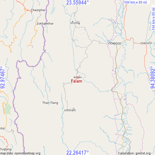
Falam GPS coordinates[2]
22° 54' 48.06" North, 93° 40' 40.044" East
| Map corner | latitude | longitude |
|---|---|---|
| Upper-left | 23.55944°, | 92.97467° |
| Center: | 22.91335°, | 93.67779° |
| Lower-right: | 22.26417°, | 94.38092° |
| Map W x H: | 144×144 km | = 89.5×89.5mi |
| max Lat: | 25.38327° ⇑6.8% North |
| Falam: | 22.91335° |
| min Lat: | ⇓93.2% South 9.98238° |
| min Long | Falam | max Long |
| 92.89835° | 93.67779° | 99.88083° |
| W 2.7%⇐ | ⇒97.3% E |
Elevation
Elevation of Falam is 1579 m = 5180 ft, and this is 1390.1 m = 4561 ft above average elevation for this country.
| Max E: |
1768 m = 5801 ft | 1.4% |
| Falam | 1579 m 5180 ft | |
| Avg. | 188.9 m = 620 ft | |
Min E: |
5 m = 16 ft | 98.6% |
See also: Myanmar elevation on elevation.city.
Geographical zone
Falam is located in North Torrid zone (between Equator and Tropic of Cancer). Distance of this Northern Tropic circle is 58.2 km =36.2 mi to North.| Distance of | km | miles | from Falam |
|---|---|---|---|
| North Pole | 7459.3 | 4635 | to North |
| Arctic Circle | 4853.4 | 3015.8 | to North |
| Tropic Cancer | 58.2 | 36.2 | to North |
| Equator | 2547.7 | 1583.1 | to South |


Nearby cities:
15 places around Falam: (largest is in red/bold)
• Chauk
253 km =157.2 mi,  152°
152°
• Hakha
30.7 km =19.1 mi,  192°
192°
• Kyaukse
291.7 km =181.3 mi,  119°
119°
• Mandalay
268.4 km =166.8 mi,  112°
112°
• Mawlaik
109.9 km =68.3 mi,  42°
42°
• Meiktila
319.1 km =198.3 mi,  135°
135°
• Mogok
290 km =180.2 mi,  89°
89°
• Monywa
174.5 km =108.4 mi, 120°
• Myingyan
239 km =148.5 mi,  132°
132°
• Pakokku
227.6 km =141.4 mi, 140°
• Pyin Oo Lwin
301.8 km =187.5 mi, 108°
• Sagaing
263.1 km =163.5 mi, 115°
• Shwebo
210.7 km =130.9 mi,  100°
100°
• Sittwe
318.1 km =197.7 mi, 194°
• Yenangyaung
298.8 km =185.7 mi,  155°
155°
Sources, notices
• [Note1] Compared only with cities in Myanmar existing in our database
• [Src1] Map data: © OpenStreetMap contributors (CC-BY-SA)
• [Src2] Other city data from geonames.org with taken over terms of usage.
• [Src3] Geographical zone / Annual Mean Temperature by Robert A. Rohde @ Wikipedia
