Hakha geodata
Hakha (Chin) is a seat of a first-order administrative division; located in Myanmar in Asia/Yangon (GMT+6.5) time zone. With population of 20,000 people, there are 64 cities with bigger population in this country. Compared to other cities in Myanmar, 91.9% of cities are located further ↓South; 98.6% of cities are located further →East and 100% of cities have lower elevation than Hakha. Note1


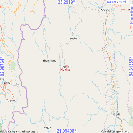
Hakha GPS coordinates[2]
22° 38' 40.272" North, 93° 36' 38.736" East
| Map corner | latitude | longitude |
|---|---|---|
| Upper-left | 23.2919°, | 92.90764° |
| Center: | 22.64452°, | 93.61076° |
| Lower-right: | 21.99408°, | 94.31389° |
| Map W x H: | 144.3×144.3 km | = 89.7×89.7mi |
| max Lat: | 25.38327° ⇑8.1% North |
| Hakha: | 22.64452° |
| min Lat: | ⇓91.9% South 9.98238° |
| min Long | Hakha | max Long |
| 92.89835° | 93.61076° | 99.88083° |
| W 1.4%⇐ | ⇒98.6% E |
Elevation
Elevation of Hakha is 1768 m = 5801 ft, and this is 1579.1 m = 5181 ft above average elevation for this country.
| Max E: |
1768 m = 5801 ft | 0% |
| Hakha | 1768 m 5801 ft | |
| Avg. | 188.9 m = 620 ft | |
Min E: |
5 m = 16 ft | 100% |
See also: Myanmar elevation on elevation.city.
Geographical zone
Hakha is located in North Torrid zone (between Equator and Tropic of Cancer). Distance of this Northern Tropic circle is 88.1 km =54.7 mi to North.| Distance of | km | miles | from Hakha |
|---|---|---|---|
| North Pole | 7489.2 | 4653.6 | to North |
| Arctic Circle | 4883.3 | 3034.3 | to North |
| Tropic Cancer | 88.1 | 54.7 | to North |
| Equator | 2517.8 | 1564.5 | to South |


Nearby cities:
15 places around Hakha: (largest is in red/bold)
• Chauk
230.6 km =143.3 mi,  147°
147°
• Falam
30.7 km =19.1 mi,  12°
12°
• Kyaukse
284.5 km =176.8 mi,  113°
113°
• Mandalay
265 km =164.7 mi, 106°
• Mawlaik
137.5 km =85.4 mi,  36°
36°
• Minbu
303.7 km =188.7 mi, 154°
• Mogok
298.7 km =185.6 mi,  84°
84°
• Monywa
167.7 km =104.2 mi, 110°
• Myingyan
225.6 km =140.2 mi,  125°
125°
• Pakokku
210.4 km =130.7 mi, 133°
• Pyin Oo Lwin
300.4 km =186.7 mi,  103°
103°
• Sagaing
258.2 km =160.4 mi, 109°
• Shwebo
214.4 km =133.2 mi,  92°
92°
• Sittwe
287.4 km =178.6 mi,  194°
194°
• Yenangyaung
275.2 km =171 mi, 151°
Sources, notices
• [Note1] Compared only with cities in Myanmar existing in our database
• [Src1] Map data: © OpenStreetMap contributors (CC-BY-SA)
• [Src2] Other city data from geonames.org with taken over terms of usage.
• [Src3] Geographical zone / Annual Mean Temperature by Robert A. Rohde @ Wikipedia
