Mogok geodata
Mogok (Mandalay) is a populated place; located in Myanmar in Asia/Yangon (GMT+6.5) time zone. With population of 90,843 people, there are 27 cities with bigger population in this country. Compared to other cities in Myanmar, 94.6% of cities are located further ↓South; 59.5% of cities are located further ←West and 95.9% of cities have lower elevation than Mogok. Note1


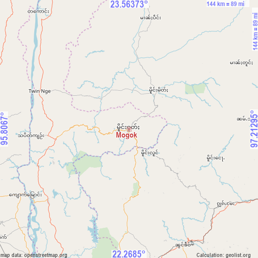
Mogok GPS coordinates[2]
22° 55' 3.576" North, 96° 30' 35.352" East
| Map corner | latitude | longitude |
|---|---|---|
| Upper-left | 23.56373°, | 95.8067° |
| Center: | 22.91766°, | 96.50982° |
| Lower-right: | 22.2685°, | 97.21295° |
| Map W x H: | 144×144 km | = 89.5×89.5mi |
| max Lat: | 25.38327° ⇑5.4% North |
| Mogok: | 22.91766° |
| min Lat: | ⇓94.6% South 9.98238° |
| min Long | Mogok | max Long |
| 92.89835° | 96.50982° | 99.88083° |
| W 59.5%⇐ | ⇒40.5% E |
Elevation
Elevation of Mogok is 1162 m = 3812 ft, and this is 973.1 m = 3193 ft above average elevation for this country.
| Max E: |
1768 m = 5801 ft | 4.1% |
| Mogok | 1162 m 3812 ft | |
| Avg. | 188.9 m = 620 ft | |
Min E: |
5 m = 16 ft | 95.9% |
See also: Mogok elevation on elevation.city.
Geographical zone
Mogok is located in North Torrid zone (between Equator and Tropic of Cancer). Distance of this Northern Tropic circle is 57.7 km =35.9 mi to North.| Distance of | km | miles | from Mogok |
|---|---|---|---|
| North Pole | 7458.9 | 4634.7 | to North |
| Arctic Circle | 4853 | 3015.5 | to North |
| Tropic Cancer | 57.7 | 35.9 | to North |
| Equator | 2548.2 | 1583.4 | to South |


Nearby cities:
15 places around Mogok: (largest is in red/bold)
• Bhamo
165.7 km =103 mi,  26°
26°
• Indein
275.3 km =171.1 mi,  172°
172°
• Kyaukse
150.9 km =93.8 mi,  194°
194°
• Lashio
127 km =78.9 mi,  89°
89°
• Mandalay
113.6 km =70.6 mi,  202°
202°
• Mawlaik
229.6 km =142.7 mi,  290°
290°
• Meiktila
236.6 km =147 mi, 196°
• Monywa
167.4 km =104 mi,  237°
237°
• Myingyan
199 km =123.7 mi,  215°
215°
• Nyaungshwe
254.7 km =158.3 mi, 170°
• Pakokku
229.2 km =142.4 mi, 219°
• Pyin Oo Lwin
98.3 km =61.1 mi,  183°
183°
• Sagaing
127.7 km =79.3 mi,  205°
205°
• Shwebo
91.8 km =57 mi,  245°
245°
• Taunggyi
242.9 km =150.9 mi, 167°
Sources, notices
• [Note1] Compared only with cities in Myanmar existing in our database
• [Src1] Map data: © OpenStreetMap contributors (CC-BY-SA)
• [Src2] Other city data from geonames.org with taken over terms of usage.
• [Src3] Geographical zone / Annual Mean Temperature by Robert A. Rohde @ Wikipedia
