Shwebo geodata
Shwebo (Sagain) is a populated place; located in Myanmar in Asia/Yangon (GMT+6.5) time zone. With population of 88,914 people, there are 30 cities with bigger population in this country. Compared to other cities in Myanmar, 90.5% of cities are located further ↓South; 66.2% of cities are located further →East and 75.7% of cities have lower elevation than Shwebo. Note1


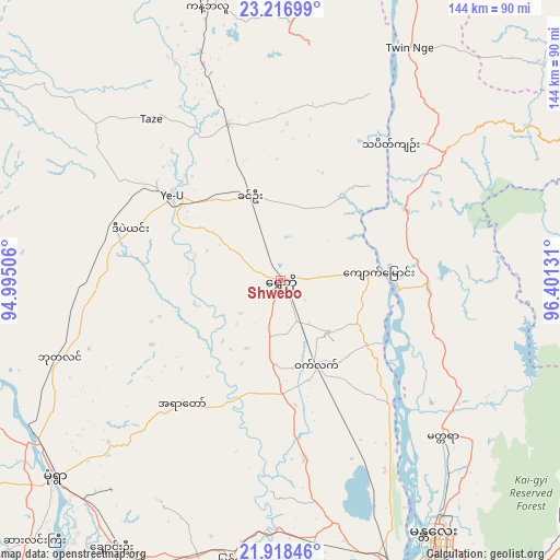
Shwebo GPS coordinates[2]
22° 34' 9.3" North, 95° 41' 53.448" East
| Map corner | latitude | longitude |
|---|---|---|
| Upper-left | 23.21699°, | 94.99506° |
| Center: | 22.56925°, | 95.69818° |
| Lower-right: | 21.91846°, | 96.40131° |
| Map W x H: | 144.4×144.4 km | = 89.7×89.7mi |
| max Lat: | 25.38327° ⇑9.5% North |
| Shwebo: | 22.56925° |
| min Lat: | ⇓90.5% South 9.98238° |
| min Long | Shwebo | max Long |
| 92.89835° | 95.69818° | 99.88083° |
| W 33.8%⇐ | ⇒66.2% E |
Elevation
Elevation of Shwebo is 111 m = 364 ft, and this is 77.9 m = 256 ft below average elevation for this country.
| Max E: |
1768 m = 5801 ft | 24.3% |
| Avg. | 188.9 m = 620 ft | |
| Shwebo | 111 m = 364 ft | |
Min E: |
5 m = 16 ft | 75.7% |
See also: Shwebo elevation on elevation.city.
Geographical zone
Shwebo is located in North Torrid zone (between Equator and Tropic of Cancer). Distance of this Northern Tropic circle is 96.5 km =60 mi to North.| Distance of | km | miles | from Shwebo |
|---|---|---|---|
| North Pole | 7497.6 | 4658.8 | to North |
| Arctic Circle | 4891.7 | 3039.6 | to North |
| Tropic Cancer | 96.5 | 60 | to North |
| Equator | 2509.5 | 1559.3 | to South |


Nearby cities:
15 places around Shwebo: (largest is in red/bold)
• Chauk
206.8 km =128.5 mi,  206°
206°
• Falam
210.7 km =130.9 mi,  280°
280°
• Hakha
214.4 km =133.2 mi,  272°
272°
• Kyaukse
116.2 km =72.2 mi,  157°
157°
• Lashio
214.3 km =133.2 mi,  79°
79°
• Mandalay
77.1 km =47.9 mi,  149°
149°
• Mawlaik
178.2 km =110.7 mi,  312°
312°
• Meiktila
188.8 km =117.3 mi,  174°
174°
• Mogok
91.8 km =57 mi,  65°
65°
• Monywa
77.3 km =48 mi,  228°
228°
• Myingyan
127.4 km =79.2 mi,  194°
194°
• Pakokku
151.1 km =93.9 mi,  204°
204°
• Pyin Oo Lwin
98.1 km =61 mi,  127°
127°
• Sagaing
82.1 km =51 mi, 159°
• Taunggyi
241.5 km =150.1 mi, 145°
Sources, notices
• [Note1] Compared only with cities in Myanmar existing in our database
• [Src1] Map data: © OpenStreetMap contributors (CC-BY-SA)
• [Src2] Other city data from geonames.org with taken over terms of usage.
• [Src3] Geographical zone / Annual Mean Temperature by Robert A. Rohde @ Wikipedia
