Chipoka geodata
Chipoka (Central Region) is a populated place; located in Malawi in Africa/Blantyre (GMT+2) time zone. With population of 4,346 people, there are 29 cities with bigger population in this country. Compared to other cities in Malawi, 54.3% of cities are located further ↓South; 54.3% of cities are located further →East and 94.3% of cities have higher elevation than Chipoka. Note1


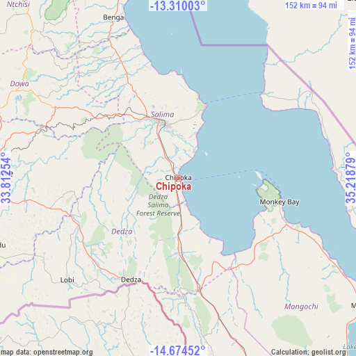
Chipoka GPS coordinates[2]
13° 59' 35.844" South, 34° 30' 56.376" East
| Map corner | latitude | longitude |
|---|---|---|
| Upper-left | -13.31003°, | 33.81254° |
| Center: | -13.99329°, | 34.51566° |
| Lower-right: | -14.67452°, | 35.21879° |
| Map W x H: | 151.7×151.7 km | = 94.3×94.3mi |
| max Lat: | -9.70237° ⇑45.7% North |
| Chipoka: | -13.99329° |
| min Lat: | ⇓54.3% South -16.91995° |
| min Long | Chipoka | max Long |
| 32.88019° | 34.51566° | 35.65067° |
| W 45.7%⇐ | ⇒54.3% E |
Elevation
Elevation of Chipoka is 483 m = 1585 ft, and this is 385.7 m = 1265 ft below average elevation for this country.
| Max E: |
1608 m = 5276 ft | 94.3% |
| Avg. | 868.7 m = 2850 ft | |
| Chipoka | 483 m = 1585 ft | |
Min E: |
55 m = 180 ft | 5.7% |
See also: Malawi elevation on elevation.city.
Geographical zone
Chipoka is located in South Torrid zone (between Equator and Tropic of Capricorn). Distance of this Southern Tropic circle is 1050 km =652.4 mi to South.| Distance of | km | miles | from Chipoka |
|---|---|---|---|
| Equator | 1555.9 | 966.8 | to North |
| Tropic Capricorn | 1050 | 652.4 | to South |
| Antarctic Circle | 5845.3 | 3632.1 | to South |
| South Pole | 8451.2 | 5251.3 | to South |


Nearby cities:
15 places around Chipoka: (largest is in red/bold)
• Balaka
119.4 km =74.2 mi,  156°
156°
• Dedza
47.1 km =29.3 mi,  204°
204°
• Dowa
72.9 km =45.3 mi,  301°
301°
• Kasungu
154.4 km =95.9 mi,  313°
313°
• Lilongwe
78.6 km =48.8 mi,  272°
272°
• Liwonde
141.7 km =88 mi,  147°
147°
• Machinga
155.6 km =96.7 mi, 147°
• Mangochi
97.1 km =60.3 mi,  123°
123°
• Monkey Bay
44.4 km =27.6 mi,  102°
102°
• Mponela
98.2 km =61 mi, 301°
• Neno
156.9 km =97.5 mi,  174°
174°
• Nkhotakota
120.9 km =75.1 mi,  348°
348°
• Ntcheu
92.9 km =57.7 mi, 171°
• Ntchisi
83 km =51.6 mi, 308°
• Salima
24.5 km =15.2 mi, 345°
Sources, notices
• [Note1] Compared only with cities in Malawi existing in our database
• [Src1] Map data: © OpenStreetMap contributors (CC-BY-SA)
• [Src2] Other city data from geonames.org with taken over terms of usage.
• [Src3] Geographical zone / Annual Mean Temperature by Robert A. Rohde @ Wikipedia
