Opuwo geodata
Opuwo (Kunene) is a seat of a first-order administrative division; located in Namibia in Africa/Windhoek (GMT+2) time zone. With population of 5,101 people, there are 30 cities with bigger population in this country. Compared to other cities in Namibia, 75% of cities are located further ↓South; 100% of cities are located further →East and 63.6% of cities have lower elevation than Opuwo. Note1


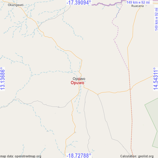
Opuwo GPS coordinates[2]
18° 3' 38.448" South, 13° 50' 23.928" East
| Map corner | latitude | longitude |
|---|---|---|
| Upper-left | -17.39094°, | 13.13686° |
| Center: | -18.06068°, | 13.83998° |
| Lower-right: | -18.72788°, | 14.54311° |
| Map W x H: | 148.7×148.7 km | = 92.4×92.4mi |
| max Lat: | -17.4° ⇑25% North |
| Opuwo: | -18.06068° |
| min Lat: | ⇓75% South -28.55° |
| min Long | Opuwo | max Long |
| 13.83998° | 13.83998° | 24.26667° |
| W 0%⇐ | ⇒100% E |
Elevation
Elevation of Opuwo is 1151 m = 3776 ft, and this is 123.2 m = 404 ft above average elevation for this country.
| Max E: |
1656 m = 5433 ft | 36.4% |
| Opuwo | 1151 m 3776 ft | |
| Avg. | 1027.8 m = 3372 ft | |
Min E: |
1 m = 3 ft | 63.6% |
See also: Namibia elevation on elevation.city.
Geographical zone
Opuwo is located in South Torrid zone (between Equator and Tropic of Capricorn). Distance of this Southern Tropic circle is 597.8 km =371.5 mi to South.| Distance of | km | miles | from Opuwo |
|---|---|---|---|
| Equator | 2008.2 | 1247.8 | to North |
| Tropic Capricorn | 597.8 | 371.5 | to South |
| Antarctic Circle | 5393 | 3351.1 | to South |
| South Pole | 7998.9 | 4970.3 | to South |


Nearby cities:
14 places around Opuwo: (largest is in red/bold)
• Eenhana
272.1 km =169.1 mi,  75°
75°
• Khorixas
282.4 km =175.5 mi,  155°
155°
• Okahao
131.2 km =81.5 mi, 81°
• Omaruru
434.3 km =269.9 mi,  149°
149°
• Omuthiya
291.5 km =181.1 mi,  96°
96°
• Ondangwa
223.7 km =139 mi,  85°
85°
• Ongandjera
131.2 km =81.5 mi, 81°
• Ongwediva
206.2 km =128.1 mi, 81°
• Oshakati
199.5 km =124 mi, 81°
• Oshikango
228.5 km =142 mi,  71°
71°
• Otavi
407.8 km =253.4 mi,  115°
115°
• Otjiwarongo
397.8 km =247.2 mi,  132°
132°
• Outapi
136.2 km =84.6 mi,  62°
62°
• Outjo
333.4 km =207.2 mi, 133°
Sources, notices
• [Note1] Compared only with cities in Namibia existing in our database
• [Src1] Map data: © OpenStreetMap contributors (CC-BY-SA)
• [Src2] Other city data from geonames.org with taken over terms of usage.
• [Src3] Geographical zone / Annual Mean Temperature by Robert A. Rohde @ Wikipedia
