Outapi geodata
Outapi (Omusati) is a seat of a first-order administrative division; located in Namibia in Africa/Windhoek (GMT+2) time zone. With population of 2,640 people, there are 39 cities with bigger population in this country. Compared to other cities in Namibia, 93.2% of cities are located further ↓South; 86.4% of cities are located further →East and 56.8% of cities have lower elevation than Outapi. Note1


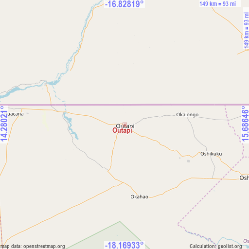
Outapi GPS coordinates[2]
17° 30' 0" South, 14° 58' 59.988" East
| Map corner | latitude | longitude |
|---|---|---|
| Upper-left | -16.82819°, | 14.28021° |
| Center: | -17.5°, | 14.98333° |
| Lower-right: | -18.16933°, | 15.68646° |
| Map W x H: | 149.1×149.1 km | = 92.6×92.6mi |
| max Lat: | -17.4° ⇑6.8% North |
| Outapi: | -17.5° |
| min Lat: | ⇓93.2% South -28.55° |
| min Long | Outapi | max Long |
| 13.83998° | 14.98333° | 24.26667° |
| W 13.6%⇐ | ⇒86.4% E |
Elevation
Elevation of Outapi is 1111 m = 3645 ft, and this is 83.2 m = 273 ft above average elevation for this country.
| Max E: |
1656 m = 5433 ft | 43.2% |
| Outapi | 1111 m 3645 ft | |
| Avg. | 1027.8 m = 3372 ft | |
Min E: |
1 m = 3 ft | 56.8% |
See also: Namibia elevation on elevation.city.
Geographical zone
Outapi is located in South Torrid zone (between Equator and Tropic of Capricorn). Distance of this Southern Tropic circle is 660.1 km =410.2 mi to South.| Distance of | km | miles | from Outapi |
|---|---|---|---|
| Equator | 1945.8 | 1209.1 | to North |
| Tropic Capricorn | 660.1 | 410.2 | to South |
| Antarctic Circle | 5455.4 | 3389.8 | to South |
| South Pole | 8061.2 | 5009 | to South |


Nearby cities:
15 places around Outapi: (largest is in red/bold)
• Eenhana
143.2 km =89 mi,  88°
88°
• Khorixas
318.7 km =198 mi,  180°
180°
• Nkurenkuru
383.6 km =238.4 mi, 91°
• Okahao
44 km =27.3 mi,  168°
168°
• Omuthiya
194.5 km =120.9 mi,  119°
119°
• Ondangwa
112.4 km =69.8 mi,  114°
114°
• Ongandjera
43.5 km =27 mi, 168°
• Ongwediva
88.8 km =55.2 mi, 110°
• Opuwo
136.2 km =84.6 mi,  242°
242°
• Oshakati
82.9 km =51.5 mi, 112°
• Oshikango
96.1 km =59.7 mi,  83°
83°
• Otavi
344.2 km =213.9 mi,  133°
133°
• Otjiwarongo
373.1 km =231.8 mi,  152°
152°
• Outjo
315.8 km =196.2 mi,  157°
157°
• Tsumeb
346.9 km =215.6 mi, 123°
Sources, notices
• [Note1] Compared only with cities in Namibia existing in our database
• [Src1] Map data: © OpenStreetMap contributors (CC-BY-SA)
• [Src2] Other city data from geonames.org with taken over terms of usage.
• [Src3] Geographical zone / Annual Mean Temperature by Robert A. Rohde @ Wikipedia
