Omuthiya geodata
Omuthiya (Oshikoto) is a seat of a first-order administrative division; located in Namibia in Africa/Windhoek (GMT+2) time zone. With population of 5,000 people, there are 31 cities with bigger population in this country. Compared to other cities in Namibia, 70.5% of cities are located further ↓South; 52.3% of cities are located further →East and 61.4% of cities have higher elevation than Omuthiya. Note1


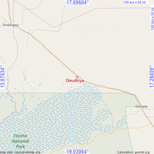
Omuthiya GPS coordinates[2]
18° 21' 52.668" South, 16° 34' 53.256" East
| Map corner | latitude | longitude |
|---|---|---|
| Upper-left | -17.69604°, | 15.87834° |
| Center: | -18.36463°, | 16.58146° |
| Lower-right: | -19.03064°, | 17.28459° |
| Map W x H: | 148.4×148.4 km | = 92.2×92.2mi |
| max Lat: | -17.4° ⇑29.5% North |
| Omuthiya: | -18.36463° |
| min Lat: | ⇓70.5% South -28.55° |
| min Long | Omuthiya | max Long |
| 13.83998° | 16.58146° | 24.26667° |
| W 47.7%⇐ | ⇒52.3% E |
Elevation
Elevation of Omuthiya is 1098 m = 3602 ft, and this is 70.2 m = 230 ft above average elevation for this country.
| Max E: |
1656 m = 5433 ft | 61.4% |
| Omuthiya | 1098 m 3602 ft | |
| Avg. | 1027.8 m = 3372 ft | |
Min E: |
1 m = 3 ft | 38.6% |
See also: Namibia elevation on elevation.city.
Geographical zone
Omuthiya is located in South Torrid zone (between Equator and Tropic of Capricorn). Distance of this Southern Tropic circle is 564 km =350.5 mi to South.| Distance of | km | miles | from Omuthiya |
|---|---|---|---|
| Equator | 2042 | 1268.8 | to North |
| Tropic Capricorn | 564 | 350.5 | to South |
| Antarctic Circle | 5359.2 | 3330.1 | to South |
| South Pole | 7965.1 | 4949.3 | to South |


Nearby cities:
15 places around Omuthiya: (largest is in red/bold)
• Eenhana
103.2 km =64.1 mi,  345°
345°
• Grootfontein
209.6 km =130.2 mi,  129°
129°
• Nkurenkuru
229.1 km =142.4 mi,  68°
68°
• Okahao
168.6 km =104.8 mi,  288°
288°
• Okakarara
262.4 km =163 mi,  160°
160°
• Ondangwa
83.3 km =51.8 mi,  306°
306°
• Ongandjera
168.8 km =104.9 mi, 288°
• Ongwediva
107.7 km =66.9 mi, 306°
• Oshakati
112.7 km =70 mi,  304°
304°
• Oshikango
130.2 km =80.9 mi,  325°
325°
• Otavi
163.3 km =101.5 mi,  151°
151°
• Otjiwarongo
233.5 km =145.1 mi,  178°
178°
• Outapi
194.5 km =120.9 mi, 299°
• Outjo
200 km =124.3 mi,  193°
193°
• Tsumeb
153.6 km =95.4 mi, 128°
Sources, notices
• [Note1] Compared only with cities in Namibia existing in our database
• [Src1] Map data: © OpenStreetMap contributors (CC-BY-SA)
• [Src2] Other city data from geonames.org with taken over terms of usage.
• [Src3] Geographical zone / Annual Mean Temperature by Robert A. Rohde @ Wikipedia
