Oshakati geodata
Oshakati (Oshana) is a seat of a first-order administrative division; located in Namibia in Africa/Windhoek (GMT+2) time zone. With population of 33,618 people, there are 3 cities with bigger population in this country. Compared to other cities in Namibia, 86.4% of cities are located further ↓South; 75% of cities are located further →East and 52.3% of cities have higher elevation than Oshakati. Note1


Oshakati GPS coordinates[2]
17° 47' 17.988" South, 15° 42' 15.696" East
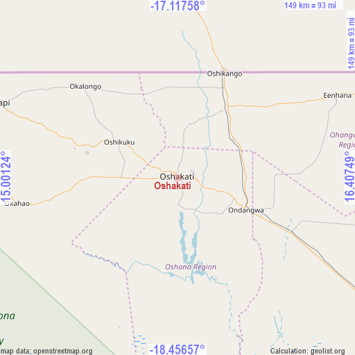
| Map corner | latitude | longitude |
|---|---|---|
| Upper-left | -17.11758°, | 15.00124° |
| Center: | -17.78833°, | 15.70436° |
| Lower-right: | -18.45657°, | 16.40749° |
| Map W x H: | 148.9×148.9 km | = 92.5×92.5mi |
| max Lat: | -17.4° ⇑13.6% North |
| Oshakati: | -17.78833° |
| min Lat: | ⇓86.4% South -28.55° |
| min Long | Oshakati | max Long |
| 13.83998° | 15.70436° | 24.26667° |
| W 25%⇐ | ⇒75% E |
Elevation
Elevation of Oshakati is 1103 m = 3619 ft, and this is 75.2 m = 247 ft above average elevation for this country.
| Max E: |
1656 m = 5433 ft | 52.3% |
| Oshakati | 1103 m 3619 ft | |
| Avg. | 1027.8 m = 3372 ft | |
Min E: |
1 m = 3 ft | 47.7% |
See also: Namibia elevation on elevation.city.
Geographical zone
Oshakati is located in South Torrid zone (between Equator and Tropic of Capricorn). Distance of this Southern Tropic circle is 628 km =390.2 mi to South.| Distance of | km | miles | from Oshakati |
|---|---|---|---|
| Equator | 1977.9 | 1229 | to North |
| Tropic Capricorn | 628 | 390.2 | to South |
| Antarctic Circle | 5423.3 | 3369.9 | to South |
| South Pole | 8029.2 | 4989.1 | to South |


Nearby cities:
15 places around Oshakati: (largest is in red/bold)
• Eenhana
75.6 km =47 mi,  61°
61°
• Khorixas
297 km =184.5 mi,  195°
195°
• Nkurenkuru
307.3 km =190.9 mi,  86°
86°
• Okahao
68.4 km =42.5 mi,  260°
260°
• Omuthiya
112.7 km =70 mi,  124°
124°
• Ondangwa
29.7 km =18.5 mi, 118°
• Ongandjera
68.3 km =42.4 mi, 261°
• Ongwediva
6.6 km =4.1 mi, 85°
• Opuwo
199.5 km =124 mi, 261°
• Oshikango
47.2 km =29.3 mi,  23°
23°
• Otavi
268.8 km =167 mi,  140°
140°
• Otjiwarongo
313.5 km =194.8 mi,  161°
161°
• Outapi
82.9 km =51.5 mi,  292°
292°
• Outjo
263.1 km =163.5 mi,  169°
169°
• Tsumeb
266.1 km =165.3 mi,  127°
127°
Sources, notices
• [Note1] Compared only with cities in Namibia existing in our database
• [Src1] Map data: © OpenStreetMap contributors (CC-BY-SA)
• [Src2] Other city data from geonames.org with taken over terms of usage.
• [Src3] Geographical zone / Annual Mean Temperature by Robert A. Rohde @ Wikipedia
