Outjo geodata
Outjo (Kunene) is a populated place; located in Namibia in Africa/Windhoek (GMT+2) time zone. With population of 6,557 people, there are 27 cities with bigger population in this country. Compared to other cities in Namibia, 61.4% of cities are located further ↓South; 59.1% of cities are located further →East and 75% of cities have lower elevation than Outjo. Note1


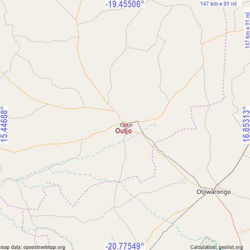
Outjo GPS coordinates[2]
20° 7' 0.012" South, 16° 9' 0" East
| Map corner | latitude | longitude |
|---|---|---|
| Upper-left | -19.45506°, | 15.44688° |
| Center: | -20.11667°, | 16.15° |
| Lower-right: | -20.77549°, | 16.85313° |
| Map W x H: | 146.8×146.8 km | = 91.2×91.2mi |
| max Lat: | -17.4° ⇑38.6% North |
| Outjo: | -20.11667° |
| min Lat: | ⇓61.4% South -28.55° |
| min Long | Outjo | max Long |
| 13.83998° | 16.15° | 24.26667° |
| W 40.9%⇐ | ⇒59.1% E |
Elevation
Elevation of Outjo is 1270 m = 4167 ft, and this is 242.2 m = 795 ft above average elevation for this country.
| Max E: |
1656 m = 5433 ft | 25% |
| Outjo | 1270 m 4167 ft | |
| Avg. | 1027.8 m = 3372 ft | |
Min E: |
1 m = 3 ft | 75% |
See also: Namibia elevation on elevation.city.
Geographical zone
Outjo is located in South Torrid zone (between Equator and Tropic of Capricorn). Distance of this Southern Tropic circle is 369.2 km =229.4 mi to South.| Distance of | km | miles | from Outjo |
|---|---|---|---|
| Equator | 2236.8 | 1389.9 | to North |
| Tropic Capricorn | 369.2 | 229.4 | to South |
| Antarctic Circle | 5164.4 | 3209 | to South |
| South Pole | 7770.3 | 4828.2 | to South |


Nearby cities:
15 places around Outjo: (largest is in red/bold)
• Grootfontein
214.6 km =133.3 mi,  73°
73°
• Karibib
204.6 km =127.1 mi,  189°
189°
• Khorixas
126.5 km =78.6 mi,  257°
257°
• Okahandja
222.3 km =138.1 mi,  159°
159°
• Okakarara
143.5 km =89.2 mi,  111°
111°
• Omaruru
148.1 km =92 mi, 188°
• Omuthiya
200 km =124.3 mi,  13°
13°
• Ondangwa
245.5 km =152.5 mi,  355°
355°
• Ongwediva
262.6 km =163.2 mi,  351°
351°
• Oshakati
263.1 km =163.5 mi, 349°
• Otavi
134.2 km =83.4 mi, 67°
• Otjimbingwe
248.3 km =154.3 mi,  180°
180°
• Otjiwarongo
64.7 km =40.2 mi,  126°
126°
• Tsumeb
191.2 km =118.8 mi,  59°
59°
• Usakos
217 km =134.8 mi,  195°
195°
Sources, notices
• [Note1] Compared only with cities in Namibia existing in our database
• [Src1] Map data: © OpenStreetMap contributors (CC-BY-SA)
• [Src2] Other city data from geonames.org with taken over terms of usage.
• [Src3] Geographical zone / Annual Mean Temperature by Robert A. Rohde @ Wikipedia
