Eenhana geodata
Eenhana (Ohangwena) is a seat of a first-order administrative division; located in Namibia in Africa/Windhoek (GMT+2) time zone. In our database, there are 43 cities with bigger population. Compared to other cities in Namibia, 97.7% of cities are located further ↓South; 56.8% of cities are located further →East and 61.4% of cities have lower elevation than Eenhana. Note1


Eenhana GPS coordinates[2]
17° 28' 0.012" South, 16° 19' 59.988" East
| Map corner | latitude | longitude |
|---|---|---|
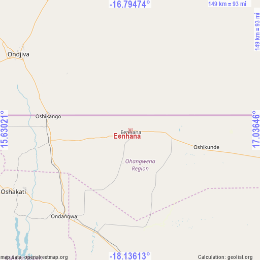
| Upper-left | -16.79474°, | 15.63021° |
| Center: | -17.46667°, | 16.33333° |
| Lower-right: | -18.13613°, | 17.03646° |
| Map W x H: | 149.1×149.2 km | = 92.6×92.7mi |
| max Lat: | -17.4° ⇑2.3% North |
| Eenhana: | -17.46667° |
| min Lat: | ⇓97.7% South -28.55° |
| min Long | Eenhana | max Long |
| 13.83998° | 16.33333° | 24.26667° |
| W 43.2%⇐ | ⇒56.8% E |
Elevation
Elevation of Eenhana is 1121 m = 3678 ft, and this is 93.2 m = 306 ft above average elevation for this country.
| Max E: |
1656 m = 5433 ft | 38.6% |
| Eenhana | 1121 m 3678 ft | |
| Avg. | 1027.8 m = 3372 ft | |
Min E: |
1 m = 3 ft | 61.4% |
See also: Namibia elevation on elevation.city.
Geographical zone
Eenhana is located in South Torrid zone (between Equator and Tropic of Capricorn). Distance of this Southern Tropic circle is 663.8 km =412.5 mi to South.| Distance of | km | miles | from Eenhana |
|---|---|---|---|
| Equator | 1942.1 | 1206.8 | to North |
| Tropic Capricorn | 663.8 | 412.5 | to South |
| Antarctic Circle | 5459.1 | 3392.1 | to South |
| South Pole | 8065 | 5011.4 | to South |


Nearby cities:
15 places around Eenhana: (largest is in red/bold)
• Grootfontein
299.8 km =186.3 mi,  141°
141°
• Nkurenkuru
240.9 km =149.7 mi,  93°
93°
• Okahao
142.1 km =88.3 mi,  250°
250°
• Omuthiya
103.2 km =64.1 mi,  165°
165°
• Ondangwa
64.4 km =40 mi,  219°
219°
• Ongandjera
142 km =88.2 mi, 250°
• Ongwediva
69.6 km =43.2 mi,  239°
239°
• Opuwo
272.1 km =169.1 mi,  255°
255°
• Oshakati
75.6 km =47 mi, 241°
• Oshikango
48.3 km =30 mi,  278°
278°
• Otavi
264.7 km =164.5 mi,  156°
156°
• Otjiwarongo
334.9 km =208.1 mi, 174°
• Outapi
143.2 km =89 mi,  268°
268°
• Outjo
295.3 km =183.5 mi,  183°
183°
• Tsumeb
244.7 km =152 mi, 143°
Sources, notices
• [Note1] Compared only with cities in Namibia existing in our database
• [Src1] Map data: © OpenStreetMap contributors (CC-BY-SA)
• [Src2] Other city data from geonames.org with taken over terms of usage.
• [Src3] Geographical zone / Annual Mean Temperature by Robert A. Rohde @ Wikipedia
