Otavi geodata
Otavi (Otjozondjupa) is a populated place; located in Namibia in Africa/Windhoek (GMT+2) time zone. With population of 4,562 people, there are 32 cities with bigger population in this country. Compared to other cities in Namibia, 63.6% of cities are located further ↓South; 65.9% of cities are located further ←West and 88.6% of cities have lower elevation than Otavi. Note1


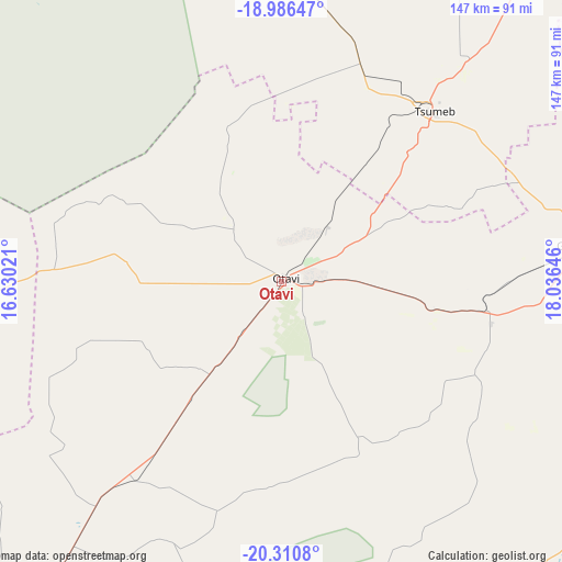
Otavi GPS coordinates[2]
19° 39' 0" South, 17° 19' 59.988" East
| Map corner | latitude | longitude |
|---|---|---|
| Upper-left | -18.98647°, | 16.63021° |
| Center: | -19.65°, | 17.33333° |
| Lower-right: | -20.3108°, | 18.03646° |
| Map W x H: | 147.3×147.3 km | = 91.5×91.5mi |
| max Lat: | -17.4° ⇑36.4% North |
| Otavi: | -19.65° |
| min Lat: | ⇓63.6% South -28.55° |
| min Long | Otavi | max Long |
| 13.83998° | 17.33333° | 24.26667° |
| W 65.9%⇐ | ⇒34.1% E |
Elevation
Elevation of Otavi is 1414 m = 4639 ft, and this is 386.2 m = 1267 ft above average elevation for this country.
| Max E: |
1656 m = 5433 ft | 11.4% |
| Otavi | 1414 m 4639 ft | |
| Avg. | 1027.8 m = 3372 ft | |
Min E: |
1 m = 3 ft | 88.6% |
See also: Namibia elevation on elevation.city.
Geographical zone
Otavi is located in South Torrid zone (between Equator and Tropic of Capricorn). Distance of this Southern Tropic circle is 421 km =261.6 mi to South.| Distance of | km | miles | from Otavi |
|---|---|---|---|
| Equator | 2184.9 | 1357.6 | to North |
| Tropic Capricorn | 421 | 261.6 | to South |
| Antarctic Circle | 5216.3 | 3241.3 | to South |
| South Pole | 7822.2 | 4860.5 | to South |


Nearby cities:
15 places around Otavi: (largest is in red/bold)
• Eenhana
264.7 km =164.5 mi,  336°
336°
• Grootfontein
82.6 km =51.3 mi,  83°
83°
• Khorixas
259.8 km =161.4 mi,  252°
252°
• Nkurenkuru
262.5 km =163.1 mi,  30°
30°
• Okahandja
263 km =163.4 mi,  189°
189°
• Okakarara
104.3 km =64.8 mi,  174°
174°
• Omaruru
246.1 km =152.9 mi,  216°
216°
• Omuthiya
163.3 km =101.5 mi,  331°
331°
• Ondangwa
241.6 km =150.1 mi,  322°
322°
• Ongwediva
265.1 km =164.7 mi, 321°
• Oshakati
268.8 km =167 mi, 320°
• Oshikango
293.2 km =182.2 mi, 328°
• Otjiwarongo
115.4 km =71.7 mi, 218°
• Outjo
134.2 km =83.4 mi, 247°
• Tsumeb
61.3 km =38.1 mi,  40°
40°
Sources, notices
• [Note1] Compared only with cities in Namibia existing in our database
• [Src1] Map data: © OpenStreetMap contributors (CC-BY-SA)
• [Src2] Other city data from geonames.org with taken over terms of usage.
• [Src3] Geographical zone / Annual Mean Temperature by Robert A. Rohde @ Wikipedia
