Omaruru geodata
Omaruru (Erongo) is a populated place; located in Namibia in Africa/Windhoek (GMT+2) time zone. With population of 11,547 people, there are 17 cities with bigger population in this country. Compared to other cities in Namibia, 52.3% of cities are located further ↓South; 65.9% of cities are located further →East and 70.5% of cities have lower elevation than Omaruru. Note1


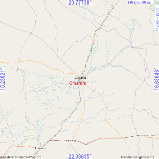
Omaruru GPS coordinates[2]
21° 25' 59.988" South, 15° 55' 59.988" East
| Map corner | latitude | longitude |
|---|---|---|
| Upper-left | -20.77738°, | 15.23021° |
| Center: | -21.43333°, | 15.93333° |
| Lower-right: | -22.08635°, | 16.63646° |
| Map W x H: | 145.5×145.5 km | = 90.4×90.4mi |
| max Lat: | -17.4° ⇑47.7% North |
| Omaruru: | -21.43333° |
| min Lat: | ⇓52.3% South -28.55° |
| min Long | Omaruru | max Long |
| 13.83998° | 15.93333° | 24.26667° |
| W 34.1%⇐ | ⇒65.9% E |
Elevation
Elevation of Omaruru is 1206 m = 3957 ft, and this is 178.2 m = 585 ft above average elevation for this country.
| Max E: |
1656 m = 5433 ft | 29.5% |
| Omaruru | 1206 m 3957 ft | |
| Avg. | 1027.8 m = 3372 ft | |
Min E: |
1 m = 3 ft | 70.5% |
See also: Namibia elevation on elevation.city.
Geographical zone
Omaruru is located in South Torrid zone (between Equator and Tropic of Capricorn). Distance of this Southern Tropic circle is 222.8 km =138.4 mi to South.| Distance of | km | miles | from Omaruru |
|---|---|---|---|
| Equator | 2383.2 | 1480.9 | to North |
| Tropic Capricorn | 222.8 | 138.4 | to South |
| Antarctic Circle | 5018 | 3118 | to South |
| South Pole | 7623.9 | 4737.3 | to South |


Nearby cities:
15 places around Omaruru: (largest is in red/bold)
• Arandis
148 km =92 mi,  222°
222°
• Hentiesbaai
186.5 km =115.9 mi,  245°
245°
• Karibib
56.5 km =35.1 mi,  190°
190°
• Katutura
167.9 km =104.3 mi,  136°
136°
• Khorixas
155.4 km =96.6 mi,  319°
319°
• Okahandja
118.6 km =73.7 mi,  121°
121°
• Okakarara
182.1 km =113.2 mi,  58°
58°
• Otjimbingwe
104 km =64.6 mi,  168°
168°
• Otjiwarongo
130.9 km =81.3 mi,  34°
34°
• Outjo
148.1 km =92 mi,  8°
8°
• Rehoboth
240.8 km =149.6 mi,  150°
150°
• Swakopmund
200.4 km =124.5 mi,  226°
226°
• Usakos
71.8 km =44.6 mi,  208°
208°
• Walvis Bay
224.4 km =139.4 mi, 220°
• Windhoek
172.4 km =107.1 mi, 136°
Sources, notices
• [Note1] Compared only with cities in Namibia existing in our database
• [Src1] Map data: © OpenStreetMap contributors (CC-BY-SA)
• [Src2] Other city data from geonames.org with taken over terms of usage.
• [Src3] Geographical zone / Annual Mean Temperature by Robert A. Rohde @ Wikipedia
