Ongwediva geodata
Ongwediva (Oshana) is a populated place; located in Namibia in Africa/Windhoek (GMT+2) time zone. With population of 9,654 people, there are 19 cities with bigger population in this country. Compared to other cities in Namibia, 88.6% of cities are located further ↓South; 72.7% of cities are located further →East and 61.4% of cities have higher elevation than Ongwediva. Note1


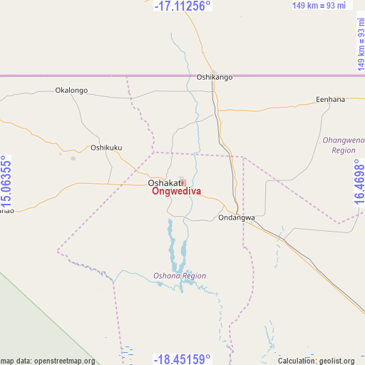
Ongwediva GPS coordinates[2]
17° 46' 59.988" South, 15° 46' 0.012" East
| Map corner | latitude | longitude |
|---|---|---|
| Upper-left | -17.11256°, | 15.06355° |
| Center: | -17.78333°, | 15.76667° |
| Lower-right: | -18.45159°, | 16.4698° |
| Map W x H: | 148.9×148.9 km | = 92.5×92.5mi |
| max Lat: | -17.4° ⇑11.4% North |
| Ongwediva: | -17.78333° |
| min Lat: | ⇓88.6% South -28.55° |
| min Long | Ongwediva | max Long |
| 13.83998° | 15.76667° | 24.26667° |
| W 27.3%⇐ | ⇒72.7% E |
Elevation
Elevation of Ongwediva is 1098 m = 3602 ft, and this is 70.2 m = 230 ft above average elevation for this country.
| Max E: |
1656 m = 5433 ft | 61.4% |
| Ongwediva | 1098 m 3602 ft | |
| Avg. | 1027.8 m = 3372 ft | |
Min E: |
1 m = 3 ft | 38.6% |
See also: Namibia elevation on elevation.city.
Geographical zone
Ongwediva is located in South Torrid zone (between Equator and Tropic of Capricorn). Distance of this Southern Tropic circle is 628.6 km =390.6 mi to South.| Distance of | km | miles | from Ongwediva |
|---|---|---|---|
| Equator | 1977.3 | 1228.6 | to North |
| Tropic Capricorn | 628.6 | 390.6 | to South |
| Antarctic Circle | 5423.9 | 3370.3 | to South |
| South Pole | 8029.7 | 4989.4 | to South |


Nearby cities:
15 places around Ongwediva: (largest is in red/bold)
• Eenhana
69.6 km =43.2 mi,  59°
59°
• Khorixas
299.3 km =186 mi,  196°
196°
• Nkurenkuru
300.7 km =186.8 mi,  86°
86°
• Okahao
75 km =46.6 mi,  261°
261°
• Omuthiya
107.7 km =66.9 mi,  126°
126°
• Ondangwa
24.4 km =15.2 mi, 127°
• Ongandjera
74.9 km =46.5 mi, 261°
• Opuwo
206.2 km =128.1 mi, 261°
• Oshakati
6.6 km =4.1 mi,  265°
265°
• Oshikango
44.4 km =27.6 mi,  16°
16°
• Otavi
265.1 km =164.7 mi,  141°
141°
• Otjiwarongo
312.1 km =193.9 mi,  162°
162°
• Outapi
88.8 km =55.2 mi,  290°
290°
• Outjo
262.6 km =163.2 mi,  171°
171°
• Tsumeb
261.3 km =162.4 mi, 128°
Sources, notices
• [Note1] Compared only with cities in Namibia existing in our database
• [Src1] Map data: © OpenStreetMap contributors (CC-BY-SA)
• [Src2] Other city data from geonames.org with taken over terms of usage.
• [Src3] Geographical zone / Annual Mean Temperature by Robert A. Rohde @ Wikipedia
