Kundiawa geodata
Kundiawa (Chimbu) is a seat of a first-order administrative division; located in Papua New Guinea in Pacific/Port_Moresby (GMT+10) time zone. With population of 9,383 people, there are 18 cities with bigger population in this country. Compared to other cities in Papua New Guinea, 54.5% of cities are located further ↓South; 59.1% of cities are located further →East and 75% of cities have lower elevation than Kundiawa. Note1


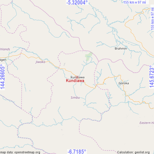
Kundiawa GPS coordinates[2]
6° 1' 10.992" South, 144° 58' 9.012" East
| Map corner | latitude | longitude |
|---|---|---|
| Upper-left | -5.32004°, | 144.26605° |
| Center: | -6.01972°, | 144.96917° |
| Lower-right: | -6.7185°, | 145.6723° |
| Map W x H: | 155.5×155.5 km | = 96.6×96.6mi |
| max Lat: | -2.0341° ⇑45.5% North |
| Kundiawa: | -6.01972° |
| min Lat: | ⇓54.5% South -10.61038° |
| min Long | Kundiawa | max Long |
| 141.29061° | 144.96917° | 155.69147° |
| W 40.9%⇐ | ⇒59.1% E |
Elevation
Elevation of Kundiawa is 1525 m = 5003 ft, and this is 944 m = 3097 ft above average elevation for this country.
| Max E: |
2248 m = 7375 ft | 25% |
| Kundiawa | 1525 m 5003 ft | |
| Avg. | 581 m = 1906 ft | |
Min E: |
0 m = 0 ft | 75% |
See also: Papua New Guinea elevation on elevation.city.
Geographical zone
Kundiawa is located in South Torrid zone (between Equator and Tropic of Capricorn). Distance of Equator is 669.3 km =415.9 mi to North.| Distance of | km | miles | from Kundiawa |
|---|---|---|---|
| Equator | 669.3 | 415.9 | to North |
| Tropic Capricorn | 1936.6 | 1203.3 | to South |
| Antarctic Circle | 6731.8 | 4182.9 | to South |
| South Pole | 9337.7 | 5802.2 | to South |


Nearby cities:
15 places around Kundiawa: (largest is in red/bold)
• Bulolo
226.7 km =140.9 mi,  125°
125°
• Goroka
46.7 km =29 mi,  98°
98°
• Ialibu
111.7 km =69.4 mi,  254°
254°
• Ihu
213.8 km =132.8 mi,  167°
167°
• Kainantu
103.5 km =64.3 mi,  106°
106°
• Kurumul
41.6 km =25.8 mi,  296°
296°
• Laiagam
151.2 km =94 mi, 300°
• Madang
126.7 km =78.7 mi,  45°
45°
• Mendi
145.8 km =90.6 mi,  264°
264°
• Minj
33.1 km =20.6 mi,  292°
292°
• Mount Hagen
83.7 km =52 mi,  282°
282°
• Porgera
210.8 km =131 mi, 287°
• Rauna
81.6 km =50.7 mi, 292°
• Tari
224.5 km =139.5 mi,  274°
274°
• Wabag
150 km =93.2 mi, 293°
Sources, notices
• [Note1] Compared only with cities in Papua New Guinea existing in our database
• [Src1] Map data: © OpenStreetMap contributors (CC-BY-SA)
• [Src2] Other city data from geonames.org with taken over terms of usage.
• [Src3] Geographical zone / Annual Mean Temperature by Robert A. Rohde @ Wikipedia
