Mount Hagen geodata
Mount Hagen (Western Highlands) is a seat of a first-order administrative division; located in Papua New Guinea in Pacific/Port_Moresby (GMT+10) time zone. With population of 33,623 people, there are 3 cities with bigger population in this country. Compared to other cities in Papua New Guinea, 59.1% of cities are located further ↓South; 68.2% of cities are located further →East and 88.6% of cities have lower elevation than Mount Hagen. Note1


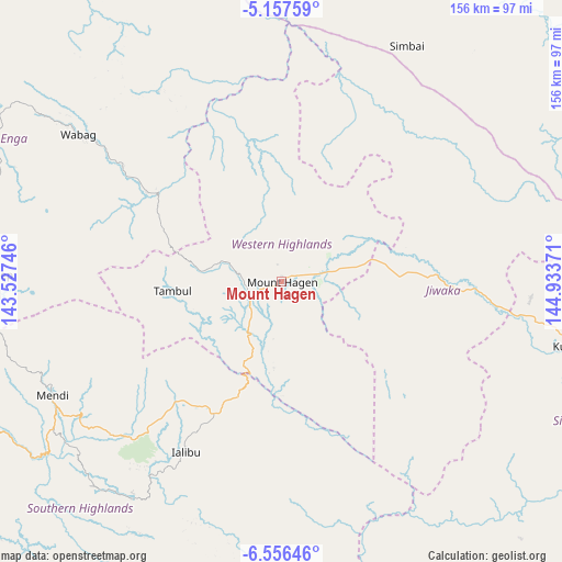
Mount Hagen GPS coordinates[2]
5° 51' 26.856" South, 144° 13' 50.088" East
| Map corner | latitude | longitude |
|---|---|---|
| Upper-left | -5.15759°, | 143.52746° |
| Center: | -5.85746°, | 144.23058° |
| Lower-right: | -6.55646°, | 144.93371° |
| Map W x H: | 155.5×155.5 km | = 96.6×96.6mi |
| max Lat: | -2.0341° ⇑40.9% North |
| Mount Hagen: | -5.85746° |
| min Lat: | ⇓59.1% South -10.61038° |
| min Long | Mount Hagen | max Long |
| 141.29061° | 144.23058° | 155.69147° |
| W 31.8%⇐ | ⇒68.2% E |
Elevation
Elevation of Mount Hagen is 1728 m = 5669 ft, and this is 1147 m = 3763 ft above average elevation for this country.
| Max E: |
2248 m = 7375 ft | 11.4% |
| Mount Hagen | 1728 m 5669 ft | |
| Avg. | 581 m = 1906 ft | |
Min E: |
0 m = 0 ft | 88.6% |
See also: Papua New Guinea elevation on elevation.city.
Geographical zone
Mount Hagen is located in South Torrid zone (between Equator and Tropic of Capricorn). Distance of Equator is 651.3 km =404.7 mi to North.| Distance of | km | miles | from Mount Hagen |
|---|---|---|---|
| Equator | 651.3 | 404.7 | to North |
| Tropic Capricorn | 1954.6 | 1214.5 | to South |
| Antarctic Circle | 6749.9 | 4194.2 | to South |
| South Pole | 9355.8 | 5813.4 | to South |


Nearby cities:
15 places around Mount Hagen: (largest is in red/bold)
• Ambunti
240.3 km =149.3 mi,  319°
319°
• Angoram
200.4 km =124.5 mi,  354°
354°
• Goroka
130.3 km =81 mi,  101°
101°
• Ialibu
54 km =33.6 mi,  209°
209°
• Kainantu
187 km =116.2 mi, 104°
• Kundiawa
83.7 km =52 mi, 102°
• Kurumul
44.3 km =27.5 mi,  89°
89°
• Laiagam
76.1 km =47.3 mi, 320°
• Madang
186.2 km =115.7 mi,  67°
67°
• Mendi
71.2 km =44.2 mi,  243°
243°
• Minj
51.3 km =31.9 mi, 96°
• Porgera
127.6 km =79.3 mi,  290°
290°
• Rauna
15 km =9.3 mi,  25°
25°
• Tari
142 km =88.2 mi,  270°
270°
• Wabag
69.5 km =43.2 mi,  305°
305°
Sources, notices
• [Note1] Compared only with cities in Papua New Guinea existing in our database
• [Src1] Map data: © OpenStreetMap contributors (CC-BY-SA)
• [Src2] Other city data from geonames.org with taken over terms of usage.
• [Src3] Geographical zone / Annual Mean Temperature by Robert A. Rohde @ Wikipedia
