Rauna geodata
Rauna (Western Highlands) is a seat of a third-order administrative division; located in Papua New Guinea in Pacific/Port_Moresby (GMT+10) time zone. In our database, there are 39 cities with bigger population. Compared to other cities in Papua New Guinea, 65.9% of cities are located further ↓South; 65.9% of cities are located further →East and 79.5% of cities have lower elevation than Rauna. Note1


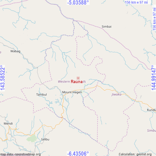
Rauna GPS coordinates[2]
5° 44' 9.24" South, 144° 17' 18.024" East
| Map corner | latitude | longitude |
|---|---|---|
| Upper-left | -5.03588°, | 143.58522° |
| Center: | -5.7359°, | 144.28834° |
| Lower-right: | -6.43506°, | 144.99147° |
| Map W x H: | 155.6×155.6 km | = 96.7×96.7mi |
| max Lat: | -2.0341° ⇑34.1% North |
| Rauna: | -5.7359° |
| min Lat: | ⇓65.9% South -10.61038° |
| min Long | Rauna | max Long |
| 141.29061° | 144.28834° | 155.69147° |
| W 34.1%⇐ | ⇒65.9% E |
Elevation
Elevation of Rauna is 1587 m = 5207 ft, and this is 1006 m = 3301 ft above average elevation for this country.
| Max E: |
2248 m = 7375 ft | 20.5% |
| Rauna | 1587 m 5207 ft | |
| Avg. | 581 m = 1906 ft | |
Min E: |
0 m = 0 ft | 79.5% |
See also: Papua New Guinea elevation on elevation.city.
Geographical zone
Rauna is located in South Torrid zone (between Equator and Tropic of Capricorn). Distance of Equator is 637.8 km =396.3 mi to North.| Distance of | km | miles | from Rauna |
|---|---|---|---|
| Equator | 637.8 | 396.3 | to North |
| Tropic Capricorn | 1968.1 | 1222.9 | to South |
| Antarctic Circle | 6763.4 | 4202.6 | to South |
| South Pole | 9369.3 | 5821.8 | to South |


Nearby cities:
15 places around Rauna: (largest is in red/bold)
• Ambunti
234.6 km =145.8 mi,  316°
316°
• Angoram
187.7 km =116.6 mi,  352°
352°
• Goroka
127.5 km =79.2 mi,  107°
107°
• Ialibu
68.9 km =42.8 mi,  208°
208°
• Kainantu
184.9 km =114.9 mi, 109°
• Kundiawa
81.6 km =50.7 mi, 112°
• Kurumul
40.2 km =25 mi, 109°
• Laiagam
71.1 km =44.2 mi,  309°
309°
• Madang
175.5 km =109.1 mi,  70°
70°
• Mendi
83.5 km =51.9 mi,  236°
236°
• Minj
48.5 km =30.1 mi, 113°
• Mount Hagen
15 km =9.3 mi, 205°
• Porgera
129.8 km =80.7 mi,  283°
283°
• Tari
148.9 km =92.5 mi,  265°
265°
• Wabag
68.4 km =42.5 mi,  293°
293°
Sources, notices
• [Note1] Compared only with cities in Papua New Guinea existing in our database
• [Src1] Map data: © OpenStreetMap contributors (CC-BY-SA)
• [Src2] Other city data from geonames.org with taken over terms of usage.
• [Src3] Geographical zone / Annual Mean Temperature by Robert A. Rohde @ Wikipedia
