Şāmitah geodata
Şāmitah (Jizan) is a populated place; located in Saudi Arabia in Asia/Riyadh (GMT+3) time zone. With population of 26,945 people, there are 49 cities with bigger population in this country. Compared to other cities in Saudi Arabia, 99% of cities are located further ↑North; 55.7% of cities are located further →East and 74.2% of cities have higher elevation than Şāmitah. Note1


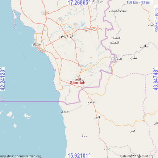
Şāmitah GPS coordinates[2]
16° 35' 45.636" North, 42° 56' 39.66" East
| Map corner | latitude | longitude |
|---|---|---|
| Upper-left | 17.26865°, | 42.24123° |
| Center: | 16.59601°, | 42.94435° |
| Lower-right: | 15.92101°, | 43.64748° |
| Map W x H: | 149.8×149.8 km | = 93.1×93.1mi |
| max Lat: | 31.67252° ⇑99% North |
| Şāmitah: | 16.59601° |
| min Lat: | ⇓1% South 16.57946° |
| min Long | Şāmitah | max Long |
| 35.69014° | 42.94435° | 54.09599° |
| W 44.3%⇐ | ⇒55.7% E |
Elevation
Elevation of Şāmitah is 62 m = 203 ft, and this is 459.4 m = 1507 ft below average elevation for this country.
| Max E: |
2385 m = 7825 ft | 74.2% |
| Avg. | 521.4 m = 1711 ft | |
| Şāmitah | 62 m = 203 ft | |
Min E: |
3 m = 10 ft | 25.8% |
See also: Saudi Arabia elevation on elevation.city.
Geographical zone
Şāmitah is located in North Torrid zone (between Equator and Tropic of Cancer). Distance of this Northern Tropic circle is 760.6 km =472.6 mi to North.| Distance of | km | miles | from Şāmitah |
|---|---|---|---|
| North Pole | 8161.8 | 5071.5 | to North |
| Arctic Circle | 5555.9 | 3452.3 | to North |
| Tropic Cancer | 760.6 | 472.6 | to North |
| Equator | 1845.3 | 1146.6 | to South |


Nearby cities:
15 places around Şāmitah: (largest is in red/bold)
• Abha
186.1 km =115.6 mi,  345°
345°
• Abū ‘Arīsh
43.1 km =26.8 mi,  343°
343°
• Ad Darb
145.3 km =90.3 mi,  329°
329°
• Al Jarādīyah
3.9 km =2.4 mi,  241°
241°
• Al Majāridah
301.6 km =187.4 mi, 338°
• An Nimāş
296.6 km =184.3 mi, 342°
• Farasān
88.8 km =55.2 mi,  277°
277°
• Jizan
53.1 km =33 mi,  307°
307°
• Khamis Mushait
190.8 km =118.6 mi, 353°
• Mislīyah
104.5 km =64.9 mi, 336°
• Mizhirah
34.1 km =21.2 mi,  318°
318°
• Najrān
160.6 km =99.8 mi,  51°
51°
• Qal‘at Bīshah
380.2 km =236.2 mi, 354°
• Tabālah
377.3 km =234.4 mi, 351°
• Şabyā
70.3 km =43.7 mi, 331°
Sources, notices
• [Note1] Compared only with cities in Saudi Arabia existing in our database
• [Src1] Map data: © OpenStreetMap contributors (CC-BY-SA)
• [Src2] Other city data from geonames.org with taken over terms of usage.
• [Src3] Geographical zone / Annual Mean Temperature by Robert A. Rohde @ Wikipedia
