Abū ‘Arīsh geodata
Abū ‘Arīsh (Jizan) is a populated place; located in Saudi Arabia in Asia/Riyadh (GMT+3) time zone. With population of 49,171 people, there are 37 cities with bigger population in this country. Compared to other cities in Saudi Arabia, 94.8% of cities are located further ↑North; 59.8% of cities are located further →East and 73.2% of cities have higher elevation than Abū ‘Arīsh. Note1


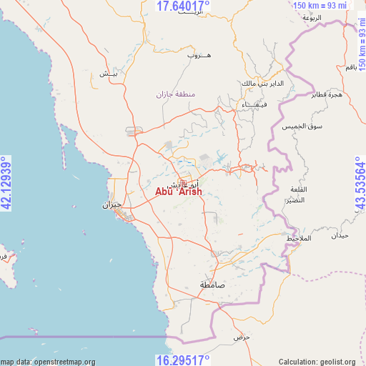
Abū ‘Arīsh GPS coordinates[2]
16° 58' 7.932" North, 42° 49' 57.036" East
| Map corner | latitude | longitude |
|---|---|---|
| Upper-left | 17.64017°, | 42.12939° |
| Center: | 16.96887°, | 42.83251° |
| Lower-right: | 16.29517°, | 43.53564° |
| Map W x H: | 149.5×149.6 km | = 92.9×93mi |
| max Lat: | 31.67252° ⇑94.8% North |
| Abū ‘Arīsh: | 16.96887° |
| min Lat: | ⇓5.2% South 16.57946° |
| min Long | Abū ‘Arīsh | max Long |
| 35.69014° | 42.83251° | 54.09599° |
| W 40.2%⇐ | ⇒59.8% E |
Elevation
Elevation of Abū ‘Arīsh is 69 m = 226 ft, and this is 452.4 m = 1484 ft below average elevation for this country.
| Max E: |
2385 m = 7825 ft | 73.2% |
| Avg. | 521.4 m = 1711 ft | |
| Abū ‘Arīsh | 69 m = 226 ft | |
Min E: |
3 m = 10 ft | 26.8% |
See also: Abū ‘Arīsh elevation on elevation.city.
Geographical zone
Abū ‘Arīsh is located in North Torrid zone (between Equator and Tropic of Cancer). Distance of this Northern Tropic circle is 719.2 km =446.9 mi to North.| Distance of | km | miles | from Abū ‘Arīsh |
|---|---|---|---|
| North Pole | 8120.3 | 5045.7 | to North |
| Arctic Circle | 5514.4 | 3426.5 | to North |
| Tropic Cancer | 719.2 | 446.9 | to North |
| Equator | 1886.8 | 1172.4 | to South |


Nearby cities:
15 places around Abū ‘Arīsh: (largest is in red/bold)
• Abha
143 km =88.9 mi,  345°
345°
• Ad Darb
104 km =64.6 mi,  323°
323°
• Al Jarādīyah
44.1 km =27.4 mi,  168°
168°
• Al Majāridah
258.6 km =160.7 mi,  337°
337°
• An Nimāş
253.5 km =157.5 mi, 342°
• Farasān
81.6 km =50.7 mi,  248°
248°
• Jizan
31.2 km =19.4 mi, 253°
• Khamis Mushait
148.4 km =92.2 mi,  355°
355°
• Mislīyah
61.9 km =38.5 mi,  331°
331°
• Mizhirah
19.1 km =11.9 mi,  213°
213°
• Najrān
149.4 km =92.8 mi,  67°
67°
• Qal‘at Bīshah
337.9 km =210 mi, 355°
• Tabālah
334.6 km =207.9 mi, 352°
• Şabyā
29.8 km =18.5 mi,  312°
312°
• Şāmitah
43.1 km =26.8 mi,  163°
163°
Sources, notices
• [Note1] Compared only with cities in Saudi Arabia existing in our database
• [Src1] Map data: © OpenStreetMap contributors (CC-BY-SA)
• [Src2] Other city data from geonames.org with taken over terms of usage.
• [Src3] Geographical zone / Annual Mean Temperature by Robert A. Rohde @ Wikipedia
