Mislīyah geodata
Mislīyah (Jizan) is a populated place; located in Saudi Arabia in Asia/Riyadh (GMT+3) time zone. With population of 6,117 people, there are 83 cities with bigger population in this country. Compared to other cities in Saudi Arabia, 92.8% of cities are located further ↑North; 64.9% of cities are located further →East and 68% of cities have higher elevation than Mislīyah. Note1


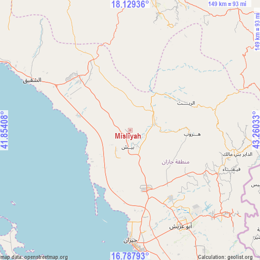
Mislīyah GPS coordinates[2]
17° 27' 35.568" North, 42° 33' 25.92" East
| Map corner | latitude | longitude |
|---|---|---|
| Upper-left | 18.12936°, | 41.85408° |
| Center: | 17.45988°, | 42.5572° |
| Lower-right: | 16.78793°, | 43.26033° |
| Map W x H: | 149.2×149.2 km | = 92.7×92.7mi |
| max Lat: | 31.67252° ⇑92.8% North |
| Mislīyah: | 17.45988° |
| min Lat: | ⇓7.2% South 16.57946° |
| min Long | Mislīyah | max Long |
| 35.69014° | 42.5572° | 54.09599° |
| W 35.1%⇐ | ⇒64.9% E |
Elevation
Elevation of Mislīyah is 127 m = 417 ft, and this is 394.4 m = 1294 ft below average elevation for this country.
| Max E: |
2385 m = 7825 ft | 68% |
| Avg. | 521.4 m = 1711 ft | |
| Mislīyah | 127 m = 417 ft | |
Min E: |
3 m = 10 ft | 32% |
See also: Saudi Arabia elevation on elevation.city.
Geographical zone
Mislīyah is located in North Torrid zone (between Equator and Tropic of Cancer). Distance of this Northern Tropic circle is 664.6 km =413 mi to North.| Distance of | km | miles | from Mislīyah |
|---|---|---|---|
| North Pole | 8065.7 | 5011.8 | to North |
| Arctic Circle | 5459.8 | 3392.6 | to North |
| Tropic Cancer | 664.6 | 413 | to North |
| Equator | 1941.4 | 1206.3 | to South |


Nearby cities:
15 places around Mislīyah: (largest is in red/bold)
• Abha
84.3 km =52.4 mi,  356°
356°
• Abū ‘Arīsh
61.9 km =38.5 mi,  151°
151°
• Ad Darb
43.6 km =27.1 mi,  312°
312°
• Al Jarādīyah
104.9 km =65.2 mi,  158°
158°
• Al Majāridah
197.2 km =122.5 mi,  339°
339°
• An Nimāş
193 km =119.9 mi,  346°
346°
• Farasān
96.3 km =59.8 mi,  208°
208°
• Jizan
63.5 km =39.5 mi,  180°
180°
• Khamis Mushait
95.3 km =59.2 mi,  11°
11°
• Mizhirah
72.9 km =45.3 mi,  165°
165°
• Najrān
166.6 km =103.5 mi,  88°
88°
• Qal‘at Bīshah
282.5 km =175.5 mi,  1°
1°
• Tabālah
277.4 km =172.4 mi, 356°
• Şabyā
35.3 km =21.9 mi, 168°
• Şāmitah
104.5 km =64.9 mi, 156°
Sources, notices
• [Note1] Compared only with cities in Saudi Arabia existing in our database
• [Src1] Map data: © OpenStreetMap contributors (CC-BY-SA)
• [Src2] Other city data from geonames.org with taken over terms of usage.
• [Src3] Geographical zone / Annual Mean Temperature by Robert A. Rohde @ Wikipedia
