Şabyā geodata
Şabyā (Jizan) is a populated place; located in Saudi Arabia in Asia/Riyadh (GMT+3) time zone. With population of 54,108 people, there are 35 cities with bigger population in this country. Compared to other cities in Saudi Arabia, 93.8% of cities are located further ↑North; 62.9% of cities are located further →East and 77.3% of cities have higher elevation than Şabyā. Note1


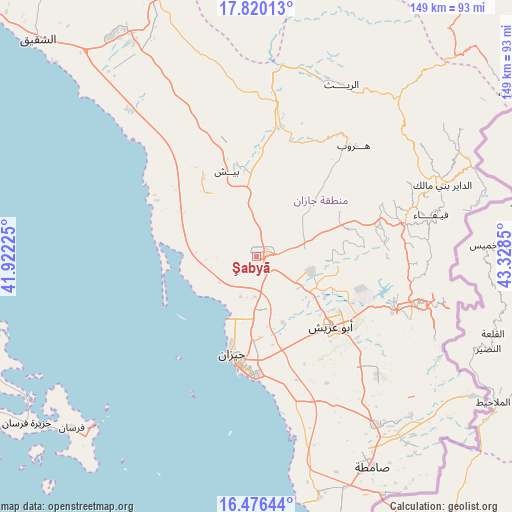
Şabyā GPS coordinates[2]
17° 8' 58.2" North, 42° 37' 31.332" East
| Map corner | latitude | longitude |
|---|---|---|
| Upper-left | 17.82013°, | 41.92225° |
| Center: | 17.1495°, | 42.62537° |
| Lower-right: | 16.47644°, | 43.3285° |
| Map W x H: | 149.4×149.4 km | = 92.8×92.8mi |
| max Lat: | 31.67252° ⇑93.8% North |
| Şabyā: | 17.1495° |
| min Lat: | ⇓6.2% South 16.57946° |
| min Long | Şabyā | max Long |
| 35.69014° | 42.62537° | 54.09599° |
| W 37.1%⇐ | ⇒62.9% E |
Elevation
Elevation of Şabyā is 36 m = 118 ft, and this is 485.4 m = 1593 ft below average elevation for this country.
| Max E: |
2385 m = 7825 ft | 77.3% |
| Avg. | 521.4 m = 1711 ft | |
| Şabyā | 36 m = 118 ft | |
Min E: |
3 m = 10 ft | 22.7% |
See also: Şabyā elevation on elevation.city.
Geographical zone
Şabyā is located in North Torrid zone (between Equator and Tropic of Cancer). Distance of this Northern Tropic circle is 699.1 km =434.4 mi to North.| Distance of | km | miles | from Şabyā |
|---|---|---|---|
| North Pole | 8100.2 | 5033.2 | to North |
| Arctic Circle | 5494.3 | 3414 | to North |
| Tropic Cancer | 699.1 | 434.4 | to North |
| Equator | 1906.8 | 1184.8 | to South |


Nearby cities:
15 places around Şabyā: (largest is in red/bold)
• Abha
119.3 km =74.1 mi,  353°
353°
• Abū ‘Arīsh
29.8 km =18.5 mi,  132°
132°
• Ad Darb
75 km =46.6 mi,  328°
328°
• Al Jarādīyah
70.4 km =43.7 mi,  154°
154°
• Al Majāridah
232.1 km =144.2 mi,  341°
341°
• An Nimāş
228.3 km =141.9 mi, 346°
• Farasān
73.4 km =45.6 mi,  227°
227°
• Jizan
30 km =18.6 mi,  195°
195°
• Khamis Mushait
128.4 km =79.8 mi,  5°
5°
• Mislīyah
35.3 km =21.9 mi, 348°
• Mizhirah
37.7 km =23.4 mi,  162°
162°
• Najrān
164 km =101.9 mi,  76°
76°
• Qal‘at Bīshah
317 km =197 mi,  359°
359°
• Tabālah
312.3 km =194.1 mi, 355°
• Şāmitah
70.3 km =43.7 mi, 151°
Sources, notices
• [Note1] Compared only with cities in Saudi Arabia existing in our database
• [Src1] Map data: © OpenStreetMap contributors (CC-BY-SA)
• [Src2] Other city data from geonames.org with taken over terms of usage.
• [Src3] Geographical zone / Annual Mean Temperature by Robert A. Rohde @ Wikipedia
