An Nimāş geodata
An Nimāş ('Asir) is a populated place; located in Saudi Arabia in Asia/Riyadh (GMT+3) time zone. With population of 24,153 people, there are 52 cities with bigger population in this country. Compared to other cities in Saudi Arabia, 86.6% of cities are located further ↑North; 70.1% of cities are located further →East and 100% of cities have lower elevation than An Nimāş. Note1


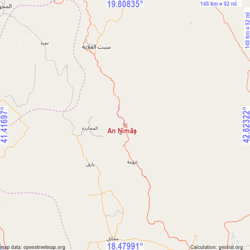
An Nimāş GPS coordinates[2]
19° 8' 43.692" North, 42° 7' 12.324" East
| Map corner | latitude | longitude |
|---|---|---|
| Upper-left | 19.80835°, | 41.41697° |
| Center: | 19.14547°, | 42.12009° |
| Lower-right: | 18.47991°, | 42.82322° |
| Map W x H: | 147.7×147.7 km | = 91.8×91.8mi |
| max Lat: | 31.67252° ⇑86.6% North |
| An Nimāş: | 19.14547° |
| min Lat: | ⇓13.4% South 16.57946° |
| min Long | An Nimāş | max Long |
| 35.69014° | 42.12009° | 54.09599° |
| W 29.9%⇐ | ⇒70.1% E |
Elevation
Elevation of An Nimāş is 2385 m = 7825 ft, and this is 1863.6 m = 6114 ft above average elevation for this country.
| Max E: |
2385 m = 7825 ft | 0% |
| An Nimāş | 2385 m 7825 ft | |
| Avg. | 521.4 m = 1711 ft | |
Min E: |
3 m = 10 ft | 100% |
See also: Saudi Arabia elevation on elevation.city.
Geographical zone
An Nimāş is located in North Torrid zone (between Equator and Tropic of Cancer). Distance of this Northern Tropic circle is 477.1 km =296.5 mi to North.| Distance of | km | miles | from An Nimāş |
|---|---|---|---|
| North Pole | 7878.3 | 4895.3 | to North |
| Arctic Circle | 5272.4 | 3276.1 | to North |
| Tropic Cancer | 477.1 | 296.5 | to North |
| Equator | 2128.8 | 1322.8 | to South |


Nearby cities:
15 places around An Nimāş: (largest is in red/bold)
• Abha
111 km =69 mi,  158°
158°
• Abū ‘Arīsh
253.5 km =157.5 mi, 162°
• Ad Darb
158.8 km =98.7 mi,  174°
174°
• Al Bahah
118.2 km =73.4 mi,  324°
324°
• Al Majāridah
22.1 km =13.7 mi,  263°
263°
• Al Mindak
142.7 km =88.7 mi, 322°
• Farasān
271.7 km =168.8 mi,  180°
180°
• Jizan
255 km =158.4 mi, 169°
• Khamis Mushait
114.1 km =70.9 mi,  145°
145°
• Mislīyah
193 km =119.9 mi, 166°
• Mizhirah
265.9 km =165.2 mi, 165°
• Qal‘at Bīshah
107.8 km =67 mi,  28°
28°
• Tabālah
94.1 km =58.5 mi,  18°
18°
• Turabah
235.6 km =146.4 mi,  347°
347°
• Şabyā
228.3 km =141.9 mi, 166°
Sources, notices
• [Note1] Compared only with cities in Saudi Arabia existing in our database
• [Src1] Map data: © OpenStreetMap contributors (CC-BY-SA)
• [Src2] Other city data from geonames.org with taken over terms of usage.
• [Src3] Geographical zone / Annual Mean Temperature by Robert A. Rohde @ Wikipedia
