Mizhirah geodata
Mizhirah (Jizan) is a populated place; located in Saudi Arabia in Asia/Riyadh (GMT+3) time zone. With population of 5,529 people, there are 85 cities with bigger population in this country. Compared to other cities in Saudi Arabia, 96.9% of cities are located further ↑North; 61.9% of cities are located further →East and 80.4% of cities have higher elevation than Mizhirah. Note1


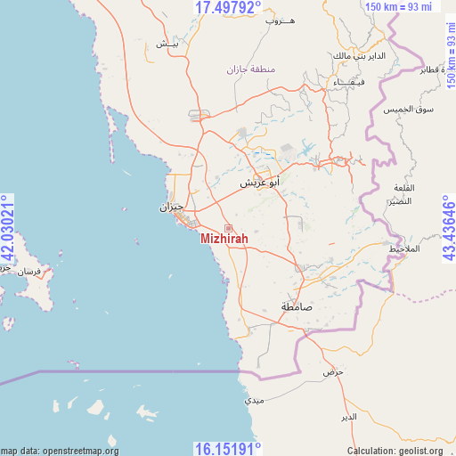
Mizhirah GPS coordinates[2]
16° 49' 33.996" North, 42° 43' 59.988" East
| Map corner | latitude | longitude |
|---|---|---|
| Upper-left | 17.49792°, | 42.03021° |
| Center: | 16.82611°, | 42.73333° |
| Lower-right: | 16.15191°, | 43.43646° |
| Map W x H: | 149.7×149.7 km | = 93×93mi |
| max Lat: | 31.67252° ⇑96.9% North |
| Mizhirah: | 16.82611° |
| min Lat: | ⇓3.1% South 16.57946° |
| min Long | Mizhirah | max Long |
| 35.69014° | 42.73333° | 54.09599° |
| W 38.1%⇐ | ⇒61.9% E |
Elevation
Elevation of Mizhirah is 21 m = 69 ft, and this is 500.4 m = 1642 ft below average elevation for this country.
| Max E: |
2385 m = 7825 ft | 80.4% |
| Avg. | 521.4 m = 1711 ft | |
| Mizhirah | 21 m = 69 ft | |
Min E: |
3 m = 10 ft | 19.6% |
See also: Saudi Arabia elevation on elevation.city.
Geographical zone
Mizhirah is located in North Torrid zone (between Equator and Tropic of Cancer). Distance of this Northern Tropic circle is 735 km =456.7 mi to North.| Distance of | km | miles | from Mizhirah |
|---|---|---|---|
| North Pole | 8136.2 | 5055.6 | to North |
| Arctic Circle | 5530.3 | 3436.4 | to North |
| Tropic Cancer | 735 | 456.7 | to North |
| Equator | 1870.9 | 1162.5 | to South |


Nearby cities:
15 places around Mizhirah: (largest is in red/bold)
• Abha
156.5 km =97.2 mi,  351°
351°
• Abū ‘Arīsh
19.1 km =11.9 mi,  33°
33°
• Ad Darb
112 km =69.6 mi,  332°
332°
• Al Jarādīyah
33.4 km =20.8 mi,  145°
145°
• Al Majāridah
269.9 km =167.7 mi,  341°
341°
• An Nimāş
265.9 km =165.2 mi, 345°
• Farasān
66.9 km =41.6 mi,  258°
258°
• Jizan
20.6 km =12.8 mi,  289°
289°
• Khamis Mushait
163.9 km =101.8 mi,  0°
0°
• Mislīyah
72.9 km =45.3 mi, 345°
• Najrān
165.7 km =103 mi,  63°
63°
• Qal‘at Bīshah
353.2 km =219.5 mi,  357°
357°
• Tabālah
349.1 km =216.9 mi, 354°
• Şabyā
37.7 km =23.4 mi, 342°
• Şāmitah
34.1 km =21.2 mi,  138°
138°
Sources, notices
• [Note1] Compared only with cities in Saudi Arabia existing in our database
• [Src1] Map data: © OpenStreetMap contributors (CC-BY-SA)
• [Src2] Other city data from geonames.org with taken over terms of usage.
• [Src3] Geographical zone / Annual Mean Temperature by Robert A. Rohde @ Wikipedia
