Tabālah geodata
Tabālah ('Asir) is a populated place; located in Saudi Arabia in Asia/Riyadh (GMT+3) time zone. With population of 5,151 people, there are 90 cities with bigger population in this country. Compared to other cities in Saudi Arabia, 85.6% of cities are located further ↑North; 68% of cities are located further →East and 90.7% of cities have lower elevation than Tabālah. Note1


Tabālah GPS coordinates[2]
19° 57' 0" North, 42° 24' 0" East
| Map corner | latitude | longitude |
|---|---|---|
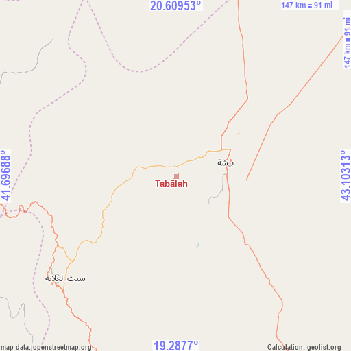
| Upper-left | 20.60953°, | 41.69688° |
| Center: | 19.95°, | 42.4° |
| Lower-right: | 19.2877°, | 43.10313° |
| Map W x H: | 147×147 km | = 91.3×91.3mi |
| max Lat: | 31.67252° ⇑85.6% North |
| Tabālah: | 19.95° |
| min Lat: | ⇓14.4% South 16.57946° |
| min Long | Tabālah | max Long |
| 35.69014° | 42.4° | 54.09599° |
| W 32%⇐ | ⇒68% E |
Elevation
Elevation of Tabālah is 1233 m = 4045 ft, and this is 711.6 m = 2335 ft above average elevation for this country.
| Max E: |
2385 m = 7825 ft | 9.3% |
| Tabālah | 1233 m 4045 ft | |
| Avg. | 521.4 m = 1711 ft | |
Min E: |
3 m = 10 ft | 90.7% |
See also: Saudi Arabia elevation on elevation.city.
Geographical zone
Tabālah is located in North Torrid zone (between Equator and Tropic of Cancer). Distance of this Northern Tropic circle is 387.7 km =240.9 mi to North.| Distance of | km | miles | from Tabālah |
|---|---|---|---|
| North Pole | 7788.8 | 4839.7 | to North |
| Arctic Circle | 5182.9 | 3220.5 | to North |
| Tropic Cancer | 387.7 | 240.9 | to North |
| Equator | 2218.2 | 1378.3 | to South |


Nearby cities:
15 places around Tabālah: (largest is in red/bold)
• Abha
193.1 km =120 mi,  176°
176°
• Ad Darb
248.1 km =154.2 mi, 183°
• Al Bahah
97.7 km =60.7 mi,  274°
274°
• Al Hadā
270.5 km =168.1 mi,  305°
305°
• Al Majāridah
105.2 km =65.4 mi,  209°
209°
• Al Mindak
118.9 km =73.9 mi,  281°
281°
• Al Muwayh
284 km =176.5 mi,  346°
346°
• An Nimāş
94.1 km =58.5 mi,  198°
198°
• Ash Shafā
250.7 km =155.8 mi,  299°
299°
• Khamis Mushait
186.8 km =116.1 mi,  169°
169°
• Mislīyah
277.4 km =172.4 mi, 176°
• Qal‘at Bīshah
22.2 km =13.8 mi,  75°
75°
• Ta’if
253.4 km =157.5 mi, 305°
• Turabah
161.6 km =100.4 mi,  330°
330°
• Şabyā
312.3 km =194.1 mi, 175°
Sources, notices
• [Note1] Compared only with cities in Saudi Arabia existing in our database
• [Src1] Map data: © OpenStreetMap contributors (CC-BY-SA)
• [Src2] Other city data from geonames.org with taken over terms of usage.
• [Src3] Geographical zone / Annual Mean Temperature by Robert A. Rohde @ Wikipedia
