Al Bahah geodata
Al Bahah is a seat of a first-order administrative division; located in Saudi Arabia in Asia/Riyadh (GMT+3) time zone. With population of 88,419 people, there are 26 cities with bigger population in this country. Compared to other cities in Saudi Arabia, 83.5% of cities are located further ↑North; 76.3% of cities are located further →East and 96.9% of cities have lower elevation than Al Bahah. Note1


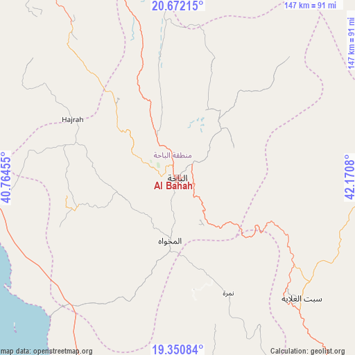
Al Bahah GPS coordinates[2]
20° 0' 46.368" North, 41° 28' 3.612" East
| Map corner | latitude | longitude |
|---|---|---|
| Upper-left | 20.67215°, | 40.76455° |
| Center: | 20.01288°, | 41.46767° |
| Lower-right: | 19.35084°, | 42.1708° |
| Map W x H: | 146.9×146.9 km | = 91.3×91.3mi |
| max Lat: | 31.67252° ⇑83.5% North |
| Al Bahah: | 20.01288° |
| min Lat: | ⇓16.5% South 16.57946° |
| min Long | Al Bahah | max Long |
| 35.69014° | 41.46767° | 54.09599° |
| W 23.7%⇐ | ⇒76.3% E |
Elevation
Elevation of Al Bahah is 2176 m = 7139 ft, and this is 1654.6 m = 5428 ft above average elevation for this country.
| Max E: |
2385 m = 7825 ft | 3.1% |
| Al Bahah | 2176 m 7139 ft | |
| Avg. | 521.4 m = 1711 ft | |
Min E: |
3 m = 10 ft | 96.9% |
See also: Al Bahah elevation on elevation.city.
Geographical zone
Al Bahah is located in North Torrid zone (between Equator and Tropic of Cancer). Distance of this Northern Tropic circle is 380.7 km =236.6 mi to North.| Distance of | km | miles | from Al Bahah |
|---|---|---|---|
| North Pole | 7781.8 | 4835.4 | to North |
| Arctic Circle | 5176 | 3216.2 | to North |
| Tropic Cancer | 380.7 | 236.6 | to North |
| Equator | 2225.2 | 1382.7 | to South |


Nearby cities:
15 places around Al Bahah: (largest is in red/bold)
• Abha
227.6 km =141.4 mi,  151°
151°
• Ad Darb
267.7 km =166.3 mi,  162°
162°
• Al Hadā
194.3 km =120.7 mi,  320°
320°
• Al Jumūm
256.2 km =159.2 mi,  314°
314°
• Al Majāridah
109.2 km =67.9 mi, 154°
• Al Mindak
25.2 km =15.7 mi, 310°
• Al Muwayh
270.8 km =168.3 mi,  6°
6°
• An Nimāş
118.2 km =73.4 mi,  144°
144°
• Ash Shafā
168.4 km =104.6 mi, 314°
• Khamis Mushait
232.3 km =144.3 mi, 145°
• Mecca
232.1 km =144.2 mi, 312°
• Qal‘at Bīshah
118.9 km =73.9 mi,  90°
90°
• Tabālah
97.7 km =60.7 mi, 94°
• Ta’if
177.6 km =110.4 mi, 321°
• Turabah
134.7 km =83.7 mi, 7°
Sources, notices
• [Note1] Compared only with cities in Saudi Arabia existing in our database
• [Src1] Map data: © OpenStreetMap contributors (CC-BY-SA)
• [Src2] Other city data from geonames.org with taken over terms of usage.
• [Src3] Geographical zone / Annual Mean Temperature by Robert A. Rohde @ Wikipedia
