Merowe geodata
Merowe (Northern State) is a populated place; located in Sudan in Africa/Khartoum (GMT+2) time zone. With population of 10,234 people, there are 61 cities with bigger population in this country. Compared to other cities in Sudan, 90.1% of cities are located further ↓South; 63.4% of cities are located further →East and 90.1% of cities have higher elevation than Merowe. Note1


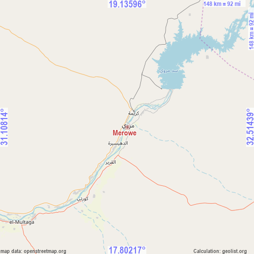
Merowe GPS coordinates[2]
18° 28' 13.296" North, 31° 48' 40.536" East
| Map corner | latitude | longitude |
|---|---|---|
| Upper-left | 19.13596°, | 31.10814° |
| Center: | 18.47036°, | 31.81126° |
| Lower-right: | 17.80217°, | 32.51439° |
| Map W x H: | 148.3×148.3 km | = 92.1×92.1mi |
| max Lat: | 21.06667° ⇑9.9% North |
| Merowe: | 18.47036° |
| min Lat: | ⇓90.1% South 10.55° |
| min Long | Merowe | max Long |
| 22.44725° | 31.81126° | 37.729° |
| W 36.6%⇐ | ⇒63.4% E |
Elevation
Elevation of Merowe is 255 m = 837 ft, and this is 194.1 m = 637 ft below average elevation for this country.
| Max E: |
1159 m = 3802 ft | 90.1% |
| Avg. | 449.1 m = 1473 ft | |
| Merowe | 255 m = 837 ft | |
Min E: |
4 m = 13 ft | 9.9% |
See also: Sudan elevation on elevation.city.
Geographical zone
Merowe is located in North Torrid zone (between Equator and Tropic of Cancer). Distance of this Northern Tropic circle is 552.2 km =343.1 mi to North.| Distance of | km | miles | from Merowe |
|---|---|---|---|
| North Pole | 7953.4 | 4942 | to North |
| Arctic Circle | 5347.5 | 3322.8 | to North |
| Tropic Cancer | 552.2 | 343.1 | to North |
| Equator | 2053.7 | 1276.1 | to South |


Nearby cities:
15 places around Merowe: (largest is in red/bold)
• Ad Dabbah
102.2 km =63.5 mi,  242°
242°
• Al Qiţena
405.2 km =251.8 mi,  171°
171°
• Argo
187.2 km =116.3 mi,  308°
308°
• Atbara
245.3 km =152.4 mi,  110°
110°
• Berber
234.7 km =145.8 mi,  102°
102°
• Dongola
161.2 km =100.2 mi,  299°
299°
• Ed Damer
248.1 km =154.2 mi, 112°
• El Bauga
222.5 km =138.3 mi, 95°
• El Matama
255.3 km =158.6 mi,  140°
140°
• Karmah an Nuzul
195.5 km =121.5 mi, 311°
• Khartoum
333.4 km =207.2 mi, 166°
• Kuraymah
9.8 km =6.1 mi,  24°
24°
• Omdurman
322.1 km =200.1 mi, 167°
• Shendi
262.1 km =162.9 mi, 138°
• Wad Rāwah
394.3 km =245 mi,  158°
158°
Sources, notices
• [Note1] Compared only with cities in Sudan existing in our database
• [Src1] Map data: © OpenStreetMap contributors (CC-BY-SA)
• [Src2] Other city data from geonames.org with taken over terms of usage.
• [Src3] Geographical zone / Annual Mean Temperature by Robert A. Rohde @ Wikipedia
