Kuraymah geodata
Kuraymah (Northern State) is a populated place; located in Sudan in Africa/Khartoum (GMT+2) time zone. With population of 19,593 people, there are 41 cities with bigger population in this country. Compared to other cities in Sudan, 91.5% of cities are located further ↓South; 62% of cities are located further →East and 90.1% of cities have higher elevation than Kuraymah. Note1


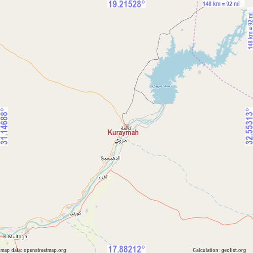
Kuraymah GPS coordinates[2]
18° 33' 0" North, 31° 51' 0" East
| Map corner | latitude | longitude |
|---|---|---|
| Upper-left | 19.21528°, | 31.14688° |
| Center: | 18.55°, | 31.85° |
| Lower-right: | 17.88212°, | 32.55313° |
| Map W x H: | 148.2×148.2 km | = 92.1×92.1mi |
| max Lat: | 21.06667° ⇑8.5% North |
| Kuraymah: | 18.55° |
| min Lat: | ⇓91.5% South 10.55° |
| min Long | Kuraymah | max Long |
| 22.44725° | 31.85° | 37.729° |
| W 38%⇐ | ⇒62% E |
Elevation
Elevation of Kuraymah is 255 m = 837 ft, and this is 194.1 m = 637 ft below average elevation for this country.
| Max E: |
1159 m = 3802 ft | 90.1% |
| Avg. | 449.1 m = 1473 ft | |
| Kuraymah | 255 m = 837 ft | |
Min E: |
4 m = 13 ft | 9.9% |
See also: Sudan elevation on elevation.city.
Geographical zone
Kuraymah is located in North Torrid zone (between Equator and Tropic of Cancer). Distance of this Northern Tropic circle is 543.4 km =337.7 mi to North.| Distance of | km | miles | from Kuraymah |
|---|---|---|---|
| North Pole | 7944.5 | 4936.5 | to North |
| Arctic Circle | 5338.6 | 3317.3 | to North |
| Tropic Cancer | 543.4 | 337.7 | to North |
| Equator | 2062.6 | 1281.6 | to South |


Nearby cities:
15 places around Kuraymah: (largest is in red/bold)
• Ad Dabbah
110.1 km =68.4 mi,  239°
239°
• Al Qiţena
413.4 km =256.9 mi,  172°
172°
• Argo
185.1 km =115 mi,  305°
305°
• Atbara
244.6 km =152 mi,  112°
112°
• Berber
232.7 km =144.6 mi,  104°
104°
• Dongola
160.6 km =99.8 mi,  295°
295°
• Ed Damer
248 km =154.1 mi,  115°
115°
• El Bauga
219.5 km =136.4 mi, 98°
• El Matama
259.5 km =161.2 mi,  142°
142°
• Karmah an Nuzul
192.8 km =119.8 mi, 308°
• Khartoum
341.2 km =212 mi, 167°
• Merowe
9.8 km =6.1 mi,  204°
204°
• Omdurman
329.9 km =205 mi, 168°
• Shendi
266.2 km =165.4 mi, 140°
• Wad Rāwah
401.1 km =249.2 mi,  159°
159°
Sources, notices
• [Note1] Compared only with cities in Sudan existing in our database
• [Src1] Map data: © OpenStreetMap contributors (CC-BY-SA)
• [Src2] Other city data from geonames.org with taken over terms of usage.
• [Src3] Geographical zone / Annual Mean Temperature by Robert A. Rohde @ Wikipedia
