Dilling geodata
Dilling (Southern Kordofan) is a populated place; located in Sudan in Africa/Khartoum (GMT+2) time zone. With population of 37,113 people, there are 25 cities with bigger population in this country. Compared to other cities in Sudan, 81.7% of cities are located further ↑North; 80.3% of cities are located further →East and 94.4% of cities have lower elevation than Dilling. Note1


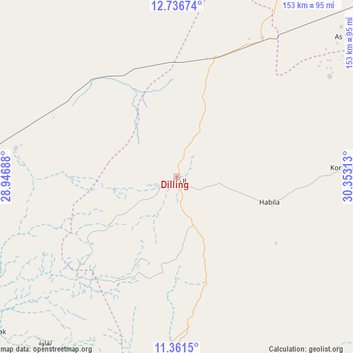
Dilling GPS coordinates[2]
12° 3' 0" North, 29° 39' 0" East
| Map corner | latitude | longitude |
|---|---|---|
| Upper-left | 12.73674°, | 28.94688° |
| Center: | 12.05°, | 29.65° |
| Lower-right: | 11.3615°, | 30.35313° |
| Map W x H: | 152.9×152.9 km | = 95×95mi |
| max Lat: | 21.06667° ⇑81.7% North |
| Dilling: | 12.05° |
| min Lat: | ⇓18.3% South 10.55° |
| min Long | Dilling | max Long |
| 22.44725° | 29.65° | 37.729° |
| W 19.7%⇐ | ⇒80.3% E |
Elevation
Elevation of Dilling is 687 m = 2254 ft, and this is 237.9 m = 781 ft above average elevation for this country.
| Max E: |
1159 m = 3802 ft | 5.6% |
| Dilling | 687 m 2254 ft | |
| Avg. | 449.1 m = 1473 ft | |
Min E: |
4 m = 13 ft | 94.4% |
See also: Sudan elevation on elevation.city.
Geographical zone
Dilling is located in North Torrid zone (between Equator and Tropic of Cancer). Distance of this Northern Tropic circle is 1266.1 km =786.7 mi to North.| Distance of | km | miles | from Dilling |
|---|---|---|---|
| North Pole | 8667.2 | 5385.5 | to North |
| Arctic Circle | 6061.3 | 3766.3 | to North |
| Tropic Cancer | 1266.1 | 786.7 | to North |
| Equator | 1339.8 | 832.5 | to South |


Nearby cities:
15 places around Dilling: (largest is in red/bold)
• Abu Jibeha
184.1 km =114.4 mi,  111°
111°
• Abū Zabad
54.8 km =34.1 mi,  307°
307°
• Al Fūlah
144.9 km =90 mi,  255°
255°
• Al Lagowa
91.6 km =56.9 mi,  217°
217°
• Al Mijlad
237.4 km =147.5 mi,  241°
241°
• An Nuhūd
150.6 km =93.6 mi,  298°
298°
• Ar Rahad
131.5 km =81.7 mi,  55°
55°
• Bārah
199.2 km =123.8 mi,  22°
22°
• El Fula
146.8 km =91.2 mi, 255°
• El Obeid
140.3 km =87.2 mi,  25°
25°
• Kadugli
115.8 km =72 mi,  176°
176°
• Marabba
277.3 km =172.3 mi,  83°
83°
• Talodi
176.6 km =109.7 mi,  153°
153°
• Tandaltī
263.5 km =163.7 mi,  65°
65°
• Umm Ruwaba
194.8 km =121 mi, 60°
Sources, notices
• [Note1] Compared only with cities in Sudan existing in our database
• [Src1] Map data: © OpenStreetMap contributors (CC-BY-SA)
• [Src2] Other city data from geonames.org with taken over terms of usage.
• [Src3] Geographical zone / Annual Mean Temperature by Robert A. Rohde @ Wikipedia
