Kédougou geodata
Kédougou is a seat of a first-order administrative division; located in Senegal in Africa/Dakar (GMT+0) time zone. With population of 17,922 people, there are 25 cities with bigger population in this country. Compared to other cities in Senegal, 98.3% of cities are located further ↑North; 100% of cities are located further ←West and 100% of cities have lower elevation than Kédougou. Note1


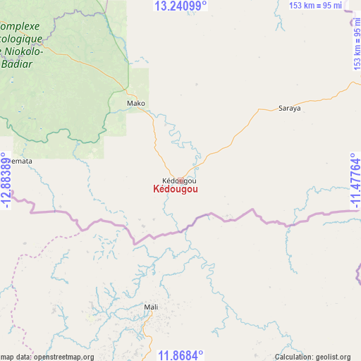
Kédougou GPS coordinates[2]
12° 33' 20.196" North, 12° 10' 50.736" West
| Map corner | latitude | longitude |
|---|---|---|
| Upper-left | 13.24099°, | -12.88389° |
| Center: | 12.55561°, | -12.18076° |
| Lower-right: | 11.8684°, | -11.47764° |
| Map W x H: | 152.6×152.6 km | = 94.8×94.8mi |
| max Lat: | 16.51293° ⇑98.3% North |
| Kédougou: | 12.55561° |
| min Lat: | ⇓1.7% South 12.485° |
| min Long | Kédougou | max Long |
| -17.47581° | -12.18076° | -12.18076° |
| W 100%⇐ | ⇒0% E |
Elevation
Elevation of Kédougou is 127 m = 417 ft, and this is 102.5 m = 336 ft above average elevation for this country.
| Max E: |
127 m = 417 ft | 0% |
| Kédougou | 127 m 417 ft | |
| Avg. | 24.5 m = 80 ft | |
Min E: |
0 m = 0 ft | 100% |
See also: Senegal elevation on elevation.city.
Geographical zone
Kédougou is located in North Torrid zone (between Equator and Tropic of Cancer). Distance of this Northern Tropic circle is 1209.9 km =751.8 mi to North.| Distance of | km | miles | from Kédougou |
|---|---|---|---|
| North Pole | 8611 | 5350.6 | to North |
| Arctic Circle | 6005.1 | 3731.4 | to North |
| Tropic Cancer | 1209.9 | 751.8 | to North |
| Equator | 1396.1 | 867.5 | to South |


Nearby cities:
15 places around Kédougou: (largest is in red/bold)
• Diawara
277 km =172.1 mi,  351°
351°
• Kaffrine
403.3 km =250.6 mi,  295°
295°
• Kanel
343.7 km =213.6 mi,  341°
341°
• Kolda
301.8 km =187.5 mi,  277°
277°
• Koungheul
324.9 km =201.9 mi, 299°
• Marsassoum
413.3 km =256.8 mi,  274°
274°
• Matam
363.7 km =226 mi, 341°
• Ouro Sogui
360.8 km =224.2 mi, 340°
• Polel Diaoubé
314.1 km =195.2 mi, 343°
• Ranérou
360.9 km =224.3 mi,  327°
327°
• Sédhiou
366.7 km =227.9 mi, 272°
• Sémé
304.8 km =189.4 mi, 344°
• Tambacounda
210.1 km =130.6 mi,  310°
310°
• Vélingara
220 km =136.7 mi,  287°
287°
• Waoundé
310.1 km =192.7 mi, 346°
Sources, notices
• [Note1] Compared only with cities in Senegal existing in our database
• [Src1] Map data: © OpenStreetMap contributors (CC-BY-SA)
• [Src2] Other city data from geonames.org with taken over terms of usage.
• [Src3] Geographical zone / Annual Mean Temperature by Robert A. Rohde @ Wikipedia
