Sémé geodata
Sémé (Matam) is a populated place; located in Senegal in Africa/Dakar (GMT+0) time zone. With population of 5,075 people, there are 51 cities with bigger population in this country. Compared to other cities in Senegal, 75% of cities are located further ↓South; 95% of cities are located further ←West and 85% of cities have lower elevation than Sémé. Note1


Sémé GPS coordinates[2]
15° 11' 39.192" North, 12° 56' 41.352" West
| Map corner | latitude | longitude |
|---|---|---|
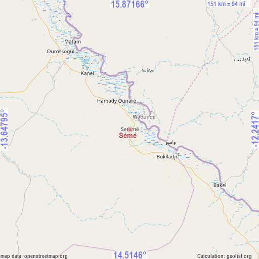
| Upper-left | 15.87166°, | -13.64795° |
| Center: | 15.19422°, | -12.94482° |
| Lower-right: | 14.5146°, | -12.2417° |
| Map W x H: | 150.9×150.9 km | = 93.8×93.8mi |
| max Lat: | 16.51293° ⇑25% North |
| Sémé: | 15.19422° |
| min Lat: | ⇓75% South 12.485° |
| min Long | Sémé | max Long |
| -17.47581° | -12.94482° | -12.18076° |
| W 95%⇐ | ⇒5% E |
Elevation
Elevation of Sémé is 42 m = 138 ft, and this is 17.5 m = 57 ft above average elevation for this country.
| Max E: |
127 m = 417 ft | 15% |
| Sémé | 42 m 138 ft | |
| Avg. | 24.5 m = 80 ft | |
Min E: |
0 m = 0 ft | 85% |
See also: Senegal elevation on elevation.city.
Geographical zone
Sémé is located in North Torrid zone (between Equator and Tropic of Cancer). Distance of this Northern Tropic circle is 916.5 km =569.5 mi to North.| Distance of | km | miles | from Sémé |
|---|---|---|---|
| North Pole | 8317.6 | 5168.3 | to North |
| Arctic Circle | 5711.7 | 3549.1 | to North |
| Tropic Cancer | 916.5 | 569.5 | to North |
| Equator | 1689.4 | 1049.7 | to South |


Nearby cities:
15 places around Sémé: (largest is in red/bold)
• Dara
272.5 km =169.3 mi,  273°
273°
• Diawara
47.1 km =29.3 mi,  113°
113°
• Goléré
171.1 km =106.3 mi,  313°
313°
• Kanel
41.3 km =25.7 mi,  323°
323°
• Koungheul
240.8 km =149.6 mi,  236°
236°
• Kédougou
304.8 km =189.4 mi,  164°
164°
• Matam
61.2 km =38 mi,  327°
327°
• Ndibène Dahra
272 km =169 mi, 273°
• Ndioum
233.8 km =145.3 mi, 308°
• Ouro Sogui
61.1 km =38 mi, 318°
• Polel Diaoubé
10 km =6.2 mi, 323°
• Ranérou
110.2 km =68.5 mi,  276°
276°
• Tambacounda
176.4 km =109.6 mi,  206°
206°
• Vélingara
260 km =161.6 mi, 209°
• Waoundé
11.3 km =7 mi,  46°
46°
Sources, notices
• [Note1] Compared only with cities in Senegal existing in our database
• [Src1] Map data: © OpenStreetMap contributors (CC-BY-SA)
• [Src2] Other city data from geonames.org with taken over terms of usage.
• [Src3] Geographical zone / Annual Mean Temperature by Robert A. Rohde @ Wikipedia
