Polel Diaoubé geodata
Polel Diaoubé (Saint-Louis) is a populated locality; located in Senegal in Africa/Dakar (GMT+0) time zone. With population of 3,000 people, there are 54 cities with bigger population in this country. Compared to other cities in Senegal, 78.3% of cities are located further ↓South; 93.3% of cities are located further ←West and 78.3% of cities have lower elevation than Polel Diaoubé. Note1


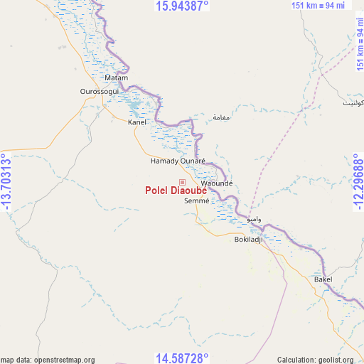
Polel Diaoubé GPS coordinates[2]
15° 16' 0.012" North, 13° 0' 0" West
| Map corner | latitude | longitude |
|---|---|---|
| Upper-left | 15.94387°, | -13.70313° |
| Center: | 15.26667°, | -13° |
| Lower-right: | 14.58728°, | -12.29688° |
| Map W x H: | 150.8×150.8 km | = 93.7×93.7mi |
| max Lat: | 16.51293° ⇑21.7% North |
| Polel Diaoubé: | 15.26667° |
| min Lat: | ⇓78.3% South 12.485° |
| min Long | Polel Diaoubé | max Long |
| -17.47581° | -13° | -12.18076° |
| W 93.3%⇐ | ⇒6.7% E |
Elevation
Elevation of Polel Diaoubé is 36 m = 118 ft, and this is 11.5 m = 38 ft above average elevation for this country.
| Max E: |
127 m = 417 ft | 21.7% |
| Polel Diaoubé | 36 m 118 ft | |
| Avg. | 24.5 m = 80 ft | |
Min E: |
0 m = 0 ft | 78.3% |
See also: Senegal elevation on elevation.city.
Geographical zone
Polel Diaoubé is located in North Torrid zone (between Equator and Tropic of Cancer). Distance of this Northern Tropic circle is 908.4 km =564.5 mi to North.| Distance of | km | miles | from Polel Diaoubé |
|---|---|---|---|
| North Pole | 8309.6 | 5163.3 | to North |
| Arctic Circle | 5703.7 | 3544.1 | to North |
| Tropic Cancer | 908.4 | 564.5 | to North |
| Equator | 1697.5 | 1054.8 | to South |


Nearby cities:
15 places around Polel Diaoubé: (largest is in red/bold)
• Dara
266.1 km =165.3 mi,  271°
271°
• Diawara
56 km =34.8 mi,  119°
119°
• Goléré
161.2 km =100.2 mi,  313°
313°
• Kaffrine
303.2 km =188.4 mi,  244°
244°
• Kanel
31.3 km =19.4 mi,  322°
322°
• Koungheul
240.5 km =149.4 mi,  233°
233°
• Matam
51.2 km =31.8 mi,  327°
327°
• Ndibène Dahra
265.7 km =165.1 mi, 271°
• Ndioum
224.1 km =139.2 mi, 308°
• Ouro Sogui
51.1 km =31.8 mi, 317°
• Ranérou
103.7 km =64.4 mi, 272°
• Sémé
10 km =6.2 mi,  143°
143°
• Tambacounda
181.2 km =112.6 mi,  203°
203°
• Vélingara
264.3 km =164.2 mi,  207°
207°
• Waoundé
14.1 km =8.8 mi,  91°
91°
Sources, notices
• [Note1] Compared only with cities in Senegal existing in our database
• [Src1] Map data: © OpenStreetMap contributors (CC-BY-SA)
• [Src2] Other city data from geonames.org with taken over terms of usage.
• [Src3] Geographical zone / Annual Mean Temperature by Robert A. Rohde @ Wikipedia
