Kanel geodata
Kanel (Matam) is a populated place; located in Senegal in Africa/Dakar (GMT+0) time zone. With population of 10,165 people, there are 39 cities with bigger population in this country. Compared to other cities in Senegal, 86.7% of cities are located further ↓South; 91.7% of cities are located further ←West and 65% of cities have lower elevation than Kanel. Note1


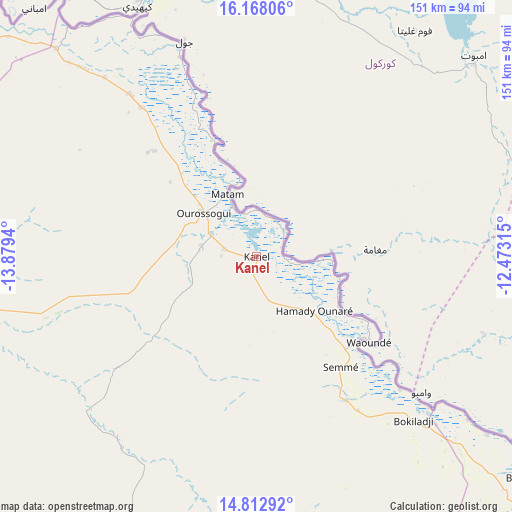
Kanel GPS coordinates[2]
15° 29' 29.76" North, 13° 10' 34.572" West
| Map corner | latitude | longitude |
|---|---|---|
| Upper-left | 16.16806°, | -13.8794° |
| Center: | 15.4916°, | -13.17627° |
| Lower-right: | 14.81292°, | -12.47315° |
| Map W x H: | 150.7×150.7 km | = 93.6×93.6mi |
| max Lat: | 16.51293° ⇑13.3% North |
| Kanel: | 15.4916° |
| min Lat: | ⇓86.7% South 12.485° |
| min Long | Kanel | max Long |
| -17.47581° | -13.17627° | -12.18076° |
| W 91.7%⇐ | ⇒8.3% E |
Elevation
Elevation of Kanel is 24 m = 79 ft, and this is 0.5 m = 2 ft below average elevation for this country.
| Max E: |
127 m = 417 ft | 35% |
| Avg. | 24.5 m = 80 ft | |
| Kanel | 24 m = 79 ft | |
Min E: |
0 m = 0 ft | 65% |
See also: Senegal elevation on elevation.city.
Geographical zone
Kanel is located in North Torrid zone (between Equator and Tropic of Cancer). Distance of this Northern Tropic circle is 883.4 km =548.9 mi to North.| Distance of | km | miles | from Kanel |
|---|---|---|---|
| North Pole | 8284.6 | 5147.8 | to North |
| Arctic Circle | 5678.7 | 3528.6 | to North |
| Tropic Cancer | 883.4 | 548.9 | to North |
| Equator | 1722.5 | 1070.3 | to South |


Nearby cities:
15 places around Kanel: (largest is in red/bold)
• Dara
247.4 km =153.7 mi,  266°
266°
• Diawara
85.6 km =53.2 mi,  127°
127°
• Goléré
130.4 km =81 mi,  310°
310°
• Koungheul
242.1 km =150.4 mi,  226°
226°
• Matam
20.1 km =12.5 mi,  335°
335°
• Ndibène Dahra
247.2 km =153.6 mi, 265°
• Ndioum
193.9 km =120.5 mi, 305°
• Ouro Sogui
20.2 km =12.6 mi, 309°
• Polel Diaoubé
31.3 km =19.4 mi,  142°
142°
• Ranérou
87.4 km =54.3 mi,  255°
255°
• Richard-Toll
290.6 km =180.6 mi,  291°
291°
• Sémé
41.3 km =25.7 mi, 143°
• Tambacounda
198.5 km =123.3 mi,  195°
195°
• Vélingara
279.4 km =173.6 mi, 201°
• Waoundé
41.6 km =25.8 mi, 127°
Sources, notices
• [Note1] Compared only with cities in Senegal existing in our database
• [Src1] Map data: © OpenStreetMap contributors (CC-BY-SA)
• [Src2] Other city data from geonames.org with taken over terms of usage.
• [Src3] Geographical zone / Annual Mean Temperature by Robert A. Rohde @ Wikipedia
