Diawara geodata
Diawara (Matam) is a populated place; located in Senegal in Africa/Dakar (GMT+0) time zone. With population of 8,112 people, there are 46 cities with bigger population in this country. Compared to other cities in Senegal, 71.7% of cities are located further ↓South; 98.3% of cities are located further ←West and 71.7% of cities have lower elevation than Diawara. Note1


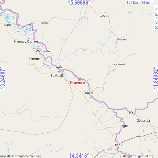
Diawara GPS coordinates[2]
15° 1' 19.056" North, 12° 32' 37.464" West
| Map corner | latitude | longitude |
|---|---|---|
| Upper-left | 15.69996°, | -13.24687° |
| Center: | 15.02196°, | -12.54374° |
| Lower-right: | 14.3418°, | -11.84062° |
| Map W x H: | 151×151 km | = 93.8×93.8mi |
| max Lat: | 16.51293° ⇑28.3% North |
| Diawara: | 15.02196° |
| min Lat: | ⇓71.7% South 12.485° |
| min Long | Diawara | max Long |
| -17.47581° | -12.54374° | -12.18076° |
| W 98.3%⇐ | ⇒1.7% E |
Elevation
Elevation of Diawara is 29 m = 95 ft, and this is 4.5 m = 15 ft above average elevation for this country.
| Max E: |
127 m = 417 ft | 28.3% |
| Diawara | 29 m 95 ft | |
| Avg. | 24.5 m = 80 ft | |
Min E: |
0 m = 0 ft | 71.7% |
See also: Senegal elevation on elevation.city.
Geographical zone
Diawara is located in North Torrid zone (between Equator and Tropic of Cancer). Distance of this Northern Tropic circle is 935.6 km =581.4 mi to North.| Distance of | km | miles | from Diawara |
|---|---|---|---|
| North Pole | 8336.8 | 5180.2 | to North |
| Arctic Circle | 5730.9 | 3561 | to North |
| Tropic Cancer | 935.6 | 581.4 | to North |
| Equator | 1670.3 | 1037.9 | to South |


Nearby cities:
15 places around Diawara: (largest is in red/bold)
• Dara
317.2 km =197.1 mi,  276°
276°
• Goléré
216 km =134.2 mi,  309°
309°
• Kanel
85.6 km =53.2 mi, 307°
• Koungheul
268.9 km =167.1 mi,  244°
244°
• Kédougou
277 km =172.1 mi,  171°
171°
• Matam
103.9 km =64.6 mi, 312°
• Ndibène Dahra
316.6 km =196.7 mi, 276°
• Ndioum
279.5 km =173.7 mi, 306°
• Ouro Sogui
105.8 km =65.7 mi, 307°
• Polel Diaoubé
56 km =34.8 mi,  299°
299°
• Ranérou
155.8 km =96.8 mi, 281°
• Sémé
47.1 km =29.3 mi,  293°
293°
• Tambacounda
184.4 km =114.6 mi,  221°
221°
• Vélingara
268.5 km =166.8 mi, 219°
• Waoundé
44 km =27.3 mi, 307°
Sources, notices
• [Note1] Compared only with cities in Senegal existing in our database
• [Src1] Map data: © OpenStreetMap contributors (CC-BY-SA)
• [Src2] Other city data from geonames.org with taken over terms of usage.
• [Src3] Geographical zone / Annual Mean Temperature by Robert A. Rohde @ Wikipedia
