Matam geodata
Matam is a seat of a first-order administrative division; located in Senegal in Africa/Dakar (GMT+0) time zone. With population of 15,306 people, there are 30 cities with bigger population in this country. Compared to other cities in Senegal, 91.7% of cities are located further ↓South; 90% of cities are located further ←West and 61.7% of cities have lower elevation than Matam. Note1


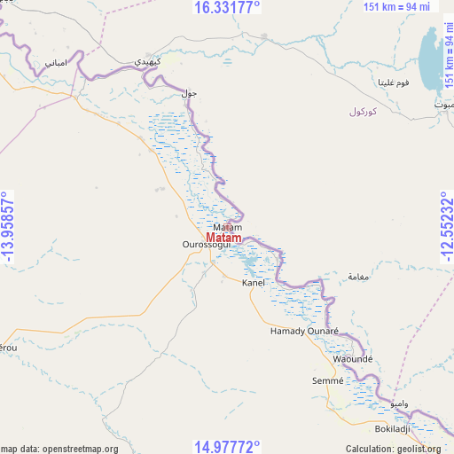
Matam GPS coordinates[2]
15° 39' 21.132" North, 13° 15' 19.584" West
| Map corner | latitude | longitude |
|---|---|---|
| Upper-left | 16.33177°, | -13.95857° |
| Center: | 15.65587°, | -13.25544° |
| Lower-right: | 14.97772°, | -12.55232° |
| Map W x H: | 150.6×150.6 km | = 93.6×93.6mi |
| max Lat: | 16.51293° ⇑8.3% North |
| Matam: | 15.65587° |
| min Lat: | ⇓91.7% South 12.485° |
| min Long | Matam | max Long |
| -17.47581° | -13.25544° | -12.18076° |
| W 90%⇐ | ⇒10% E |
Elevation
Elevation of Matam is 22 m = 72 ft, and this is 2.5 m = 8 ft below average elevation for this country.
| Max E: |
127 m = 417 ft | 38.3% |
| Avg. | 24.5 m = 80 ft | |
| Matam | 22 m = 72 ft | |
Min E: |
0 m = 0 ft | 61.7% |
See also: Senegal elevation on elevation.city.
Geographical zone
Matam is located in North Torrid zone (between Equator and Tropic of Cancer). Distance of this Northern Tropic circle is 865.1 km =537.5 mi to North.| Distance of | km | miles | from Matam |
|---|---|---|---|
| North Pole | 8266.3 | 5136.4 | to North |
| Arctic Circle | 5660.4 | 3517.2 | to North |
| Tropic Cancer | 865.1 | 537.5 | to North |
| Equator | 1740.8 | 1081.7 | to South |


Nearby cities:
15 places around Matam: (largest is in red/bold)
• Dara
240.8 km =149.6 mi,  261°
261°
• Diawara
103.9 km =64.6 mi,  132°
132°
• Goléré
112.4 km =69.8 mi,  306°
306°
• Kanel
20.1 km =12.5 mi,  155°
155°
• Koungheul
249.3 km =154.9 mi,  221°
221°
• Ndibène Dahra
240.7 km =149.6 mi, 261°
• Ndioum
176.6 km =109.7 mi,  302°
302°
• Ouro Sogui
9.1 km =5.7 mi,  232°
232°
• Polel Diaoubé
51.2 km =31.8 mi,  147°
147°
• Ranérou
85.9 km =53.4 mi,  242°
242°
• Richard-Toll
276.3 km =171.7 mi,  288°
288°
• Rosso
284.7 km =176.9 mi, 287°
• Sémé
61.2 km =38 mi, 147°
• Tambacounda
214.2 km =133.1 mi,  191°
191°
• Waoundé
60.2 km =37.4 mi,  136°
136°
Sources, notices
• [Note1] Compared only with cities in Senegal existing in our database
• [Src1] Map data: © OpenStreetMap contributors (CC-BY-SA)
• [Src2] Other city data from geonames.org with taken over terms of usage.
• [Src3] Geographical zone / Annual Mean Temperature by Robert A. Rohde @ Wikipedia
