Saint-Louis geodata
Saint-Louis is a seat of a first-order administrative division; located in Senegal in Africa/Dakar (GMT+0) time zone. With population of 176,000 people, there are 5 cities with bigger population in this country. Compared to other cities in Senegal, 93.3% of cities are located further ↓South; 68.3% of cities are located further →East and 86.7% of cities have higher elevation than Saint-Louis. Note1


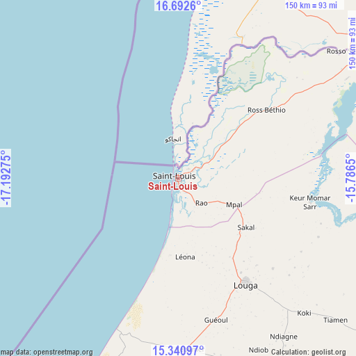
Saint-Louis GPS coordinates[2]
16° 1' 4.548" North, 16° 29' 22.632" West
| Map corner | latitude | longitude |
|---|---|---|
| Upper-left | 16.6926°, | -17.19275° |
| Center: | 16.01793°, | -16.48962° |
| Lower-right: | 15.34097°, | -15.7865° |
| Map W x H: | 150.3×150.3 km | = 93.4×93.4mi |
| max Lat: | 16.51293° ⇑6.7% North |
| Saint-Louis: | 16.01793° |
| min Lat: | ⇓93.3% South 12.485° |
| min Long | Saint-Louis | max Long |
| -17.47581° | -16.48962° | -12.18076° |
| W 31.7%⇐ | ⇒68.3% E |
Elevation
Elevation of Saint-Louis is 8 m = 26 ft, and this is 16.5 m = 54 ft below average elevation for this country.
| Max E: |
127 m = 417 ft | 86.7% |
| Avg. | 24.5 m = 80 ft | |
| Saint-Louis | 8 m = 26 ft | |
Min E: |
0 m = 0 ft | 13.3% |
See also: Saint-Louis elevation on elevation.city.
Geographical zone
Saint-Louis is located in North Torrid zone (between Equator and Tropic of Cancer). Distance of this Northern Tropic circle is 824.9 km =512.6 mi to North.| Distance of | km | miles | from Saint-Louis |
|---|---|---|---|
| North Pole | 8226 | 5111.4 | to North |
| Arctic Circle | 5620.1 | 3492.2 | to North |
| Tropic Cancer | 824.9 | 512.6 | to North |
| Equator | 1781 | 1106.7 | to South |


Nearby cities:
15 places around Saint-Louis: (largest is in red/bold)
• Dara
131.2 km =81.5 mi,  124°
124°
• Diourbel
154.6 km =96.1 mi,  170°
170°
• Guéoul
61.3 km =38.1 mi, 165°
• Kayar
139.6 km =86.7 mi,  208°
208°
• Khombole
140.9 km =87.6 mi,  189°
189°
• Louga
52.7 km =32.7 mi,  147°
147°
• Mbaké
150.1 km =93.3 mi,  155°
155°
• Mékhé
102 km =63.4 mi, 187°
• Ndibène Dahra
132.5 km =82.3 mi,  125°
125°
• Pout
151.6 km =94.2 mi,  203°
203°
• Richard-Toll
97.6 km =60.6 mi,  59°
59°
• Rosso
86.3 km =53.6 mi, 58°
• Thiès
144.4 km =89.7 mi, 198°
• Thiès Nones
146.5 km =91 mi, 200°
• Touba
145.2 km =90.2 mi, 153°
Sources, notices
• [Note1] Compared only with cities in Senegal existing in our database
• [Src1] Map data: © OpenStreetMap contributors (CC-BY-SA)
• [Src2] Other city data from geonames.org with taken over terms of usage.
• [Src3] Geographical zone / Annual Mean Temperature by Robert A. Rohde @ Wikipedia
