Dara geodata
Dara (Louga) is a populated place; located in Senegal in Africa/Dakar (GMT+0) time zone. With population of 30,000 people, there are 16 cities with bigger population in this country. Compared to other cities in Senegal, 83.3% of cities are located further ↓South; 73.3% of cities are located further ←West and 81.7% of cities have lower elevation than Dara. Note1


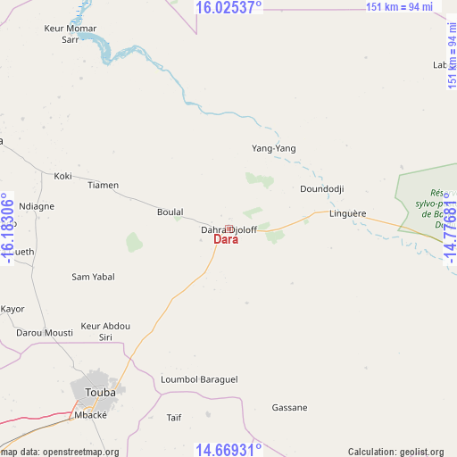
Dara GPS coordinates[2]
15° 20' 54.384" North, 15° 28' 47.748" West
| Map corner | latitude | longitude |
|---|---|---|
| Upper-left | 16.02537°, | -16.18306° |
| Center: | 15.34844°, | -15.47993° |
| Lower-right: | 14.66931°, | -14.77681° |
| Map W x H: | 150.8×150.8 km | = 93.7×93.7mi |
| max Lat: | 16.51293° ⇑16.7% North |
| Dara: | 15.34844° |
| min Lat: | ⇓83.3% South 12.485° |
| min Long | Dara | max Long |
| -17.47581° | -15.47993° | -12.18076° |
| W 73.3%⇐ | ⇒26.7% E |
Elevation
Elevation of Dara is 41 m = 135 ft, and this is 16.5 m = 54 ft above average elevation for this country.
| Max E: |
127 m = 417 ft | 18.3% |
| Dara | 41 m 135 ft | |
| Avg. | 24.5 m = 80 ft | |
Min E: |
0 m = 0 ft | 81.7% |
See also: Senegal elevation on elevation.city.
Geographical zone
Dara is located in North Torrid zone (between Equator and Tropic of Cancer). Distance of this Northern Tropic circle is 899.3 km =558.8 mi to North.| Distance of | km | miles | from Dara |
|---|---|---|---|
| North Pole | 8300.5 | 5157.7 | to North |
| Arctic Circle | 5694.6 | 3538.5 | to North |
| Tropic Cancer | 899.3 | 558.8 | to North |
| Equator | 1706.6 | 1060.4 | to South |


Nearby cities:
15 places around Dara: (largest is in red/bold)
• Diourbel
113.1 km =70.3 mi,  226°
226°
• Guinguinéo
130.5 km =81.1 mi,  202°
202°
• Guéoul
94.5 km =58.7 mi,  279°
279°
• Kaffrine
138.4 km =86 mi,  183°
183°
• Kaolack
147.5 km =91.7 mi,  205°
205°
• Khombole
146.1 km =90.8 mi,  243°
243°
• Louga
85.2 km =52.9 mi,  290°
290°
• Mbaké
77.2 km =48 mi,  216°
216°
• Mékhé
125.3 km =77.9 mi,  257°
257°
• Ndibène Dahra
1.7 km =1.1 mi,  167°
167°
• Richard-Toll
126.1 km =78.4 mi,  349°
349°
• Rosso
123.9 km =77 mi,  344°
344°
• Saint-Louis
131.2 km =81.5 mi,  304°
304°
• Tiébo
113.4 km =70.5 mi, 225°
• Touba
70.3 km =43.7 mi, 218°
Sources, notices
• [Note1] Compared only with cities in Senegal existing in our database
• [Src1] Map data: © OpenStreetMap contributors (CC-BY-SA)
• [Src2] Other city data from geonames.org with taken over terms of usage.
• [Src3] Geographical zone / Annual Mean Temperature by Robert A. Rohde @ Wikipedia
