Richard-Toll geodata
Richard-Toll (Saint-Louis) is a populated place; located in Senegal in Africa/Dakar (GMT+0) time zone. With population of 44,752 people, there are 13 cities with bigger population in this country. Compared to other cities in Senegal, 98.3% of cities are located further ↓South; 68.3% of cities are located further ←West and 93.3% of cities have higher elevation than Richard-Toll. Note1


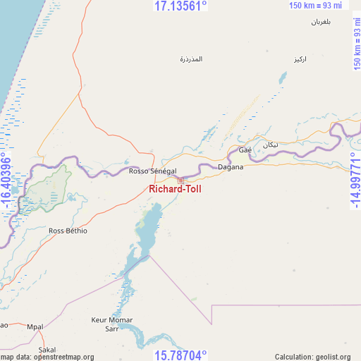
Richard-Toll GPS coordinates[2]
16° 27' 45" North, 15° 42' 2.988" West
| Map corner | latitude | longitude |
|---|---|---|
| Upper-left | 17.13561°, | -16.40396° |
| Center: | 16.4625°, | -15.70083° |
| Lower-right: | 15.78704°, | -14.99771° |
| Map W x H: | 149.9×150 km | = 93.1×93.2mi |
| max Lat: | 16.51293° ⇑1.7% North |
| Richard-Toll: | 16.4625° |
| min Lat: | ⇓98.3% South 12.485° |
| min Long | Richard-Toll | max Long |
| -17.47581° | -15.70083° | -12.18076° |
| W 68.3%⇐ | ⇒31.7% E |
Elevation
Elevation of Richard-Toll is 7 m = 23 ft, and this is 17.5 m = 57 ft below average elevation for this country.
| Max E: |
127 m = 417 ft | 93.3% |
| Avg. | 24.5 m = 80 ft | |
| Richard-Toll | 7 m = 23 ft | |
Min E: |
0 m = 0 ft | 6.7% |
See also: Richard-Toll elevation on elevation.city.
Geographical zone
Richard-Toll is located in North Torrid zone (between Equator and Tropic of Cancer). Distance of this Northern Tropic circle is 775.5 km =481.9 mi to North.| Distance of | km | miles | from Richard-Toll |
|---|---|---|---|
| North Pole | 8176.6 | 5080.7 | to North |
| Arctic Circle | 5570.7 | 3461.5 | to North |
| Tropic Cancer | 775.5 | 481.9 | to North |
| Equator | 1830.5 | 1137.4 | to South |


Nearby cities:
15 places around Richard-Toll: (largest is in red/bold)
• Dara
126.1 km =78.4 mi,  169°
169°
• Diourbel
210 km =130.5 mi,  196°
196°
• Goléré
172.2 km =107 mi,  97°
97°
• Guéoul
129.1 km =80.2 mi,  212°
212°
• Khombole
216.8 km =134.7 mi, 209°
• Louga
109.2 km =67.9 mi, 210°
• Mbaké
187.2 km =116.3 mi,  186°
186°
• Mékhé
179.8 km =111.7 mi, 213°
• Ndibène Dahra
127.8 km =79.4 mi, 169°
• Ndioum
112.5 km =69.9 mi,  87°
87°
• Ranérou
226.1 km =140.5 mi,  124°
124°
• Rosso
11.4 km =7.1 mi,  245°
245°
• Saint-Louis
97.6 km =60.6 mi,  239°
239°
• Tiébo
211.2 km =131.2 mi, 195°
• Touba
180.4 km =112.1 mi, 186°
Sources, notices
• [Note1] Compared only with cities in Senegal existing in our database
• [Src1] Map data: © OpenStreetMap contributors (CC-BY-SA)
• [Src2] Other city data from geonames.org with taken over terms of usage.
• [Src3] Geographical zone / Annual Mean Temperature by Robert A. Rohde @ Wikipedia
